25 09, 2018

Advancing Flood Risk Analytics with Location Profile APIs: Showcases

2021-01-13T12:19:35+11:00September 25th, 2018|APIs, Asia, Australia, Elevation, Emergency, Exposure, Flood, Insurance, Location Intelligence, Property Information, Risk, USA|

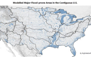
25 September 2018 For flood risk assessment, one may develop flood hazard maps directly or just use existing maps which are often associated with modelled hazard return periods. The quality of each flood map is up to a range of factors, such as the quality of elevation and rainfall inputs, modelling methods, and [...]

31 08, 2018

Location Profile APIs Out of Beta

2020-10-03T00:49:20+10:00August 31st, 2018|APIs, Asia, Asset Management, Exposure, Geospatial Big Data Analytics, Insurance, Location Intelligence, Property Information, Real Estate, Risk|

31 August 2018 We are pleased to release property/exposure Location Profile APIs (Version 2.0), out of beta! (Link to an initial release and introduction is here.) More than ten APIs are currently available for property location and hazard risk intelligence. Main applications: Property location information, emergency planning and response, insurance underwriting and claims, news media [...]

8 06, 2018

Introducing Location Profile APIs for Property Location and Hazard Risk Intelligence

2020-10-03T00:49:23+10:00June 8th, 2018|APIs, Asia, Asset Management, Australia, Exposure, Geospatial Big Data Analytics, Insurance, Location Intelligence, Property Information, Real Estate, Risk, USA|

8 June 2018 The public release of BigData Earth's Location Profile APIs is a milestone in our vision of achieving API-first, cloud-based big data analytics and innovative solutions. [Update 31 August 2018: APIs Version 2.0 out of beta] The set of APIs released now reflects our substantial R&D in the following major applications over [...]

18 04, 2018

New Dataset – ABS Socio-Economic Indexes for Areas (SEIFA) – to Enhance Property Location Profile Report

2020-10-03T00:49:23+10:00April 18th, 2018|Australia, Census, Exposure, Location Intelligence, Property Information|

18 April 2018 The Australian Bureau of Statistics (ABS) released the long-awaited Socio-Economic Indexes for Areas (SEIFA, based on 2016 Census) dataset on 27 March 2018 (link). SEIFA is a modelled measure by integrating a wide range of social and economic attributes about the Australian population in an geographic area. SEIFA is generally regarded as one [...]

21 11, 2017

Introducing Three New Tools for Investigating Flood-prone Areas in the U.S. and Australia

2020-10-03T00:49:23+10:00November 21st, 2017|Australia, Elevation, Flood, Location Intelligence, Property Information, Risk, USA|

21 November 2017 Flood mapping for large areas (e.g. from catchments to a national level) is relatively new and challenging; associating mapped flood-prone areas with an annual chance of occurrence (in probabilities, say 1%) of a flood event involves many kinds of uncertainties and is even harder. Flood maps that suggest various hazard levels over [...]

25 10, 2017

Visualising Potential Bushfire Risk for Addresses in Australia: A New Cloud-based Approach

2020-10-03T00:49:24+10:00October 25th, 2017|Australia, Bushfire, Earth Observation, Location Intelligence, News Media, Property Information, Risk|

25 October 2017 It's well known that hundreds of thousands of Australian properties (e.g. residential, commercial and industrial) at the urban-bushland interface are very prone to damaging bushfires. Increasing population, urban encroachment into bushland and a dangerous warming climate all suggest that bushfire risk is on the increase. Bushfire risk assessment has been a [...]

10 08, 2017

New Study: Rapid Exposure Accumulation in Australia’s Coastal Region from 2006 to 2016

2020-10-03T00:49:30+10:00August 10th, 2017|Australia, Census, Exposure, Location Intelligence, Property Information|

10 August 2017 In the previous post, we presented the increase of Australian population and residential dwellings from 2006 to 2016, and how they vary across States and Territories. In this post, we report how much and how fast exposure has changed in coastal regions during the same period. (Australia is sometimes seen as the world’s largest [...]

10 08, 2017

Exposure Changes in Australia: Time Series Profiles of Population and Residential Dwellings from Censuses 2006, 2011 and 2016

2020-10-03T00:49:31+10:00August 10th, 2017|Australia, Census, Exposure, Location Intelligence, Property Information|

10 August 2017 The Australian Bureau of Statistics (ABS) has recently released the first batch of 2016 Census data, and its DataPacks can be obtained here. The new time series profiles on community characteristics provide a unique perspective on how Australian exposure has been changing over the past decade. In this post, we report population [...]

27 03, 2017

The March 2017 Tropical Cyclone Debbie: Three Exposure Location Profile Reports for Sites in Townsville, Bowen and Mackay, Queensland

2021-04-16T14:55:53+10:00March 27th, 2017|Australia, Earth Observation, Location Intelligence, Major Events, Property Information|

27 March 2017 It is forecast that Tropical Cyclone Debbie will cause severe damage to the coastal region spanning from Townsville in the north to Mackay in the south. It will make landfall near Bowen. Figure 1: Latest track forecast for TC Debbie (Source: BoM) We use a newly-developed national platform to [...]

27 03, 2017

Developing Exposure Location Profile Report for Emergency and Insurance Applications: A National Platform

2020-10-03T00:49:45+10:00March 27th, 2017|Australia, Earth Observation, Image Analysis, Location Intelligence, Property Information, Real Estate|

27 March 2017 BigData Earth has been developing cloud-based solutions for delivering property (exposure) location profile reports, and one of these is for emergency and insurance applications (e.g. emergency planning and response, and insurance underwriting). For locations, addresses or sites in Australia, a national platform and web portal has been developed: https://propertylocation.com.au/georisk.html Main [...]

Go to Top