24 11, 2020

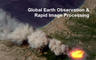
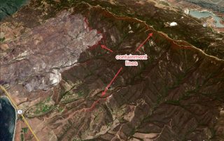
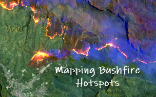
Detecting Bushfire Hotspots from Himawari-8 Imagery: With Four Examples from the 2019-20 Australian Bushfire Season

2021-01-11T22:18:53+11:00November 24th, 2020|AI, APIs, Apps, Asset Management, Australia, Bushfire, Climate Change, Cloud Computing, Earth Observation, Emergency, Geospatial Big Data Analytics, Image Analysis, Location Intelligence, Major Events, News Media, Risk, Sentinel-2|

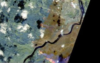
The new generation of geostationary meteorological satellites, such as Himawari-8 from the Japan Meteorological Agency (JMA, link), offer much improved capabilities of monitoring large-scale weather events in the atmosphere and phenomena on the Earth's surface. Himawari-8 sensors (Advanced Himawari Imagers - AHIs) are equipped with 16 spectral bands: 3 visible bands at 0.5 [...]

11 08, 2020

Monitoring Land Cover Changes at the Bushland-Urban Interface: An Image Analysis Approach

2020-12-11T12:13:19+11:00August 11th, 2020|AI, Australia, Bushfire, Climate Change, Cloud Computing, Earth Observation, Emergency, Exposure, Geocoding, Geospatial Big Data Analytics, Image Analysis, Land parcel, Location Intelligence, Property Information, Risk, Sentinel-2|

It has been well observed, modelled and reported that bushfire risk is on the rise under a rapidly warming climate. Earth observation, remote sensing and image analysis are among the most important technologies to manage bushfires nowadays - from disaster prevention to preparedness, from hotspots detection to movement monitoring, from response to recovery, [...]

2 04, 2020

Unique Software Spectral Discovery to Easily and Rapidly Process Sentinel-2 Imagery

2021-01-13T18:26:09+11:00April 2nd, 2020|Agriculture, Asia, Australia, Bushfire, Earth Observation, Emergency, Image Analysis, Major Events, News Media, Risk, Sentinel-2, USA, Wildfire|

2 April 2020 Sentinel-2 (with twin satellites Sentinel-2A and Sentinel-2B) is one of the most successful Earth observation missions from the EU Copernicus Programme and ESA. Sentinel-2 satellite imagery features: wide swath (290km) multiple spectral bands (13 bands) high resolution (four visible and near-infrared bands at 10m, six red-edge/shortwave-infrared bands at 20m, and three [...]

31 08, 2018

Monitoring Major Events with Global Earth Observation and Geospatial Big Data Analytics: 10+ New Examples

2020-10-03T00:49:18+10:00August 31st, 2018|Asia, Australia, Bushfire, Earth Observation, Emergency, Image Analysis, Major Events, News Media, Risk, Sentinel-2, USA, Wildfire|

31 August 2018 This blog summarises some of our latest activities of monitoring, modelling and mapping major hazardous events with Earth observation and geospatial big data analytics, the two methods that are increasingly important and indispensable for a wide range of environmental studies. We routinely apply our own advanced image analysis software (Spectral Discovery) [...]

17 11, 2016

Mapping the Early November 2016 Bushfire Burnt Areas in Sydney-Newcastle Region, with Sentinel-2 Satellite Imagery

2020-10-03T00:49:52+10:00November 17th, 2016|Australia, Bushfire, Earth Observation, Image Analysis, Major Events, Sentinel-2|

The 2016-2017 bushfire season in New South Wales started early. In early November (the last month of spring in Australia), three large bushfires broke out near populated areas and drew much attention: The fire near Cranebrook and Llandilo, Western Sydney The fire near Cessnock, Hunter Valley The fire near Karuah, ~35 km north of [...]

25 06, 2016

Mapping the June 2016 Sherpa Fire in Santa Barbara County, California, with Sentinel-2 Satellite Imagery

2020-10-03T00:49:58+10:00June 25th, 2016|Earth Observation, Image Analysis, Major Events, Sentinel-2, USA, Wildfire|

Major Event: Sherpa Fire started on June 15, 2016 (from InciWeb) Mapping Fire Scars (Burnt Areas) using the Latest Sentinel-2 Satellite Imagery Imagery Source: Public Sentinel-2 Imagery on Amazon Web Services S3 - data download link Imagery Provider: EU Earth Observation Programme - Copernicus Imagery Acquisition Date: 2016-06-21 Swath Width: 290 km Multispectral [...]

27 05, 2016

Observing the May 2016 Fort McMurray Wildfire: A Survey of Satellite Imagery Sources (including Sentinel-2)

2020-10-03T00:50:02+10:00May 27th, 2016|Canada, Earth Observation, Image Analysis, Landsat, Major Events, Sentinel-2, Wildfire|

The May 2016 Fort McMurray Wildfire in Alberta, Canada is catastrophic. The fire started on May 1, and as of May 24, is still raging. The fire has destroyed ~2,400 homes and buildings, and resulted in massive fire scars (burnt areas) over 500,000 hectares. It becomes the most expensive nature disaster in Canadian history, with an [...]

Go to Top