High-resolution Web Maps on Terrain & Hydrology
We make detailed tile maps on Terrain & Hydrology, important thematic layers in web / desktop mapping and especially useful for site-level flood hazard / risk analytics.

Two Additional Tools to Advance Flood Risk Analytics at Scale in Australia

Access Tile Maps via APIs:
Subscription Plans (PDF)

Applications of New National Contour Web Maps: Part 1 (Enhancing High-resolution Imagery Mapping)

Applications of New National Contour Web Maps: Part 2 (Identifying Low-lying Coastal Areas)

Applications of New National Contour Web Maps: Part 3 (Identifying Riverine Flood-prone Areas)

New Tile Maps on Terrain and Hydrology: Part 1 (Enriching Google Maps)

New Tile Maps on Terrain and Hydrology: Part 2 (Extending Coverage)

New Tile Maps on Terrain and Hydrology: Part 3 (Increasing Details)
Processing Service to Turn Your Geospatial Data into Tiled Web Maps
We offer separate processing service to turn your vector- or raster-based geospatial data into beautiful and scalable tile maps, which can then be accessed via APIs.
If you plan to securely and efficiently deliver your own large-sized geospatial data to many end-users (in the form of straightforward and manageable APIs), we can help carry out underlying research, prepare versatile tile maps and set up very fast, cloud-based mapping infrastructure (usually based on AWS, GCP or Azure) for you. In addition, we provide consultancies on a range of geospatial web services.

Cloud-based Geospatial Processing Service to Turn High-resolution DEMs into Feature Layers & Web Maps (PDF)

Creating Building Footprints and Terrain Features for Web and Desktop Mapping: With Examples from the NSW Coast

Mapping the Coastal Settlement in Wamberal, NSW: Two Approaches
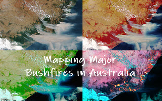
Mapping Major Bushfires in Australia using Near Real-time Himawari-8 Imagery: Access Imagery Tiles & Hotspot Feature Layers via APIs Subscription Plans