Web Apps on Exposure Analysis & Location Intelligence
We offer end-to-end solutions and develop web Apps with online mapping, analysis and reporting altogether. We can extend your data, concept and business logic to feature-rich and easy-to-use web Apps, which are further backed by the cloud infrastructure from leading vendors (e.g. AWS, GCP and Azure).
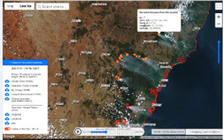
Mapping Major Bushfires in Australia using Near Real-time Himawari-8 Satellite Imagery

Creating Building Footprints and Terrain Features for Web and Desktop Mapping: With Examples from the NSW Coast
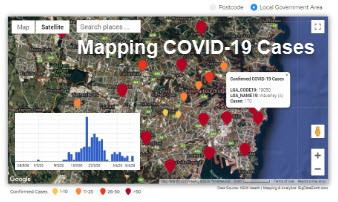
New Web App: Mapping Daily Confirmed COVID-19 Cases in NSW by Postcode and LGA

New Web Mapping, Analysis and Reporting App on Exposure Management (including Portfolio- and Site-level Exposure Analysis)

Property Location Profile Report for Real Estate Professionals

Property Location Profile Report for City Councils and Local Government Areas
