11 April 2020
Strongly motivated by the recent release of more detailed COVID-19 data by the New South Wales (NSW) Government, we have developed a new web app that maps the daily confirmed COVID-19 cases in Sydney and NSW by Postcode and Local Government Area (LGA). Please note that so far the NSW Government is the first and only State and Territory government in Australia that has released such data down to individual postcodes.
While there are many other apps keeping track of COVID-19 cases at national and global levels, our focus has been on local levels and how to effectively visualise finer resolution datasets.
Our new app is for residents who wish to check out the daily changing number (i.e. the time series) of confirmed COVID-19 cases at suburbs.
Meanwhile, contextual population data (e.g. population counts and age groups) for postcodes and LGAs is sourced from the Australian Bureau of Statistics (ABS) for display.
If you have any suggestions or comments, please let us know.
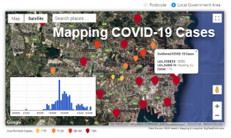
Figure 1: Screen capture – mapping confirmed COVID-19 cases in NSW by Postcode
Figure 2: Screen capture – mapping confirmed COVID-19 cases in NSW by LGA