29 01, 2021

Data & Analytics Services in Response to Major Events: New Case Studies

2021-01-30T11:17:42+11:00January 29th, 2021|APIs, Asia, Australia, Bushfire, Earth Observation, Emergency, Exposure, Geospatial Big Data Analytics, Image Analysis, Location Intelligence, Major Events, News Media, Risk, Tropical Cyclone, USA|

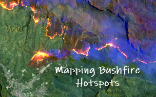
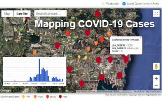
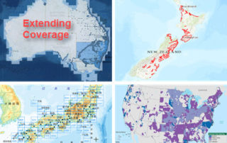
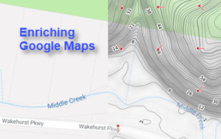
We offer data & analytics services to aid rapid response to major events, such as disasters and emergencies. In this blog, we showcase our efforts in response to a number of major events in Australia during the summer week of 20-26 January 2021. A range of information products related to a tropical low, [...]

24 11, 2020

Mapping Major Bushfires in Australia using Near Real-time Himawari-8 Satellite Imagery

2022-08-08T08:15:39+10:00November 24th, 2020|AI, APIs, Apps, Asset Management, Australia, Bushfire, Climate Change, Cloud Computing, Earth Observation, Emergency, Geospatial Big Data Analytics, Image Analysis, Location Intelligence, Major Events, Risk|

Acknowledgements: This project is made possible thanks to the availability of Himawari-8 satellite imagery from the Japan Meteorological Agency (JMA, link) and its open access provided by AWS (link). Mapping bushfires using Earth observation (EO) imagery has been a very active research and application field. With a strong determination to [...]

24 11, 2020

Detecting Bushfire Hotspots from Himawari-8 Imagery: With Four Examples from the 2019-20 Australian Bushfire Season

2021-01-11T22:18:53+11:00November 24th, 2020|AI, APIs, Apps, Asset Management, Australia, Bushfire, Climate Change, Cloud Computing, Earth Observation, Emergency, Geospatial Big Data Analytics, Image Analysis, Location Intelligence, Major Events, News Media, Risk, Sentinel-2|

The new generation of geostationary meteorological satellites, such as Himawari-8 from the Japan Meteorological Agency (JMA, link), offer much improved capabilities of monitoring large-scale weather events in the atmosphere and phenomena on the Earth's surface. Himawari-8 sensors (Advanced Himawari Imagers - AHIs) are equipped with 16 spectral bands: 3 visible bands at 0.5 [...]

11 08, 2020

Monitoring Land Cover Changes at the Bushland-Urban Interface: An Image Analysis Approach

2020-12-11T12:13:19+11:00August 11th, 2020|AI, Australia, Bushfire, Climate Change, Cloud Computing, Earth Observation, Emergency, Exposure, Geocoding, Geospatial Big Data Analytics, Image Analysis, Land parcel, Location Intelligence, Property Information, Risk, Sentinel-2|

It has been well observed, modelled and reported that bushfire risk is on the rise under a rapidly warming climate. Earth observation, remote sensing and image analysis are among the most important technologies to manage bushfires nowadays - from disaster prevention to preparedness, from hotspots detection to movement monitoring, from response to recovery, [...]

11 04, 2020

New Web App: Mapping Daily Confirmed COVID-19 Cases in NSW by Postcode and LGA

2020-11-27T23:17:39+11:00April 11th, 2020|Apps, Australia, Census, Cloud Computing, Emergency, Exposure, Geospatial Big Data Analytics, Location Intelligence, Major Events, Risk|

11 April 2020 Strongly motivated by the recent release of more detailed COVID-19 data by the New South Wales (NSW) Government, we have developed a new web app that maps the daily confirmed COVID-19 cases in Sydney and NSW by Postcode and Local Government Area (LGA). Please note that so far the [...]

2 04, 2020

Unique Software Spectral Discovery to Easily and Rapidly Process Sentinel-2 Imagery

2021-01-13T18:26:09+11:00April 2nd, 2020|Agriculture, Asia, Australia, Bushfire, Earth Observation, Emergency, Image Analysis, Major Events, News Media, Risk, Sentinel-2, USA, Wildfire|

2 April 2020 Sentinel-2 (with twin satellites Sentinel-2A and Sentinel-2B) is one of the most successful Earth observation missions from the EU Copernicus Programme and ESA. Sentinel-2 satellite imagery features: wide swath (290km) multiple spectral bands (13 bands) high resolution (four visible and near-infrared bands at 10m, six red-edge/shortwave-infrared bands at 20m, and three [...]

11 03, 2020

Top 10 Blogs of the Past Two Years from BigData Earth

2020-10-03T00:48:53+10:00March 11th, 2020|APIs, Apps, Australia, Bushfire, Cloud Computing, Emergency, Exposure, Flood, Geospatial Big Data Analytics, Insurance, Location Intelligence, Property Information, Risk, Tropical Cyclone, USA|

11 March 2020 Exactly four years ago, we started blogging what we have been exploring and creating in geospatial big data analytics, cloud computing, property location metrics, hazard and risk modelling, etc. So far, more than 50 blogs have been produced. Here we select and share top 10 blogs from the past [...]

9 12, 2019

New Tile Maps on Terrain and Hydrology: Part 3 (Increasing Details)

2020-10-03T00:48:56+10:00December 9th, 2019|APIs, Apps, Australia, Emergency, Exposure, Flood, Geospatial Big Data Analytics, Insurance, Location Intelligence, Property Information, Risk|

9 December 2019 LiDAR point clouds can represent 3D features very accurately, but due to their large data sizes, point clouds are commonly turned into easy-to-use DEMs at various spatial resolutions (e.g. 1m, 5m or 10m). Such DEMs are increasingly available via government web portals. The vertical accuracy of 1m-resolution Lidar-derived DEMs [...]

9 12, 2019

New Tile Maps on Terrain and Hydrology: Part 2 (Extending Coverage)

2020-10-03T00:48:58+10:00December 9th, 2019|APIs, Apps, Australia, Emergency, Exposure, Flood, Geospatial Big Data Analytics, Insurance, Location Intelligence, Property Information, Risk|

9 December 2019 Many of us work with elevation data (e.g. LiDAR point clouds and Digital Elevation Models - DEMs) on a daily basis. Nowadays there are an increasing number of government sources for open elevation data, including high-quality, LiDAR-derived DEMs. As we have recently introduced (link to the previous blog), elevation data [...]

18 09, 2019

New Tile Maps on Terrain and Hydrology: Part 1 (Enriching Google Maps)

2020-10-16T00:28:14+11:00September 18th, 2019|APIs, Apps, Australia, Emergency, Exposure, Flood, Geospatial Big Data Analytics, Insurance, Location Intelligence, Property Information, Risk|

18 September 2019 Google Maps is very popular and easy to use, and many of us would have imagined creating and delivering domain-specific mapping layers in the same or similar way Google Maps does. To realise this, we have recently created and released a set of new, high-resolution tiled web maps (or tile [...]

Go to Top