22 10, 2018

Advancing Tropical Cyclone Risk Analytics with Location Profile APIs

2021-03-08T14:08:28+11:00October 22nd, 2018|APIs, Asia, Australia, Emergency, Exposure, Hurricane, Insurance, Location Intelligence, Risk, Tropical Cyclone, Typhoon, USA|

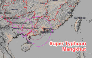
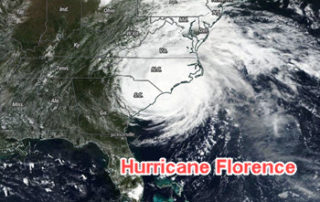
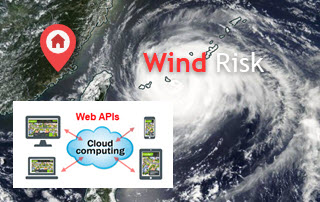
22 October 2018 This project is focused on the analysis of historical tropical cyclones (also known as hurricanes or typhoons) and related wind records, including track positions, wind speed and central pressure. We have developed an automated process of carrying out such analyses on the cloud and enabled by web APIs. A straightforward [...]

21 09, 2018

The September 2018 Super Typhoon Mangkhut: Some Rapid Risk Analyses

2020-10-03T00:49:17+10:00September 21st, 2018|APIs, Asia, Earth Observation, Exposure, Flood, Hurricane, Image Analysis, Insurance, Location Intelligence, Major Events, Tropical Cyclone, Typhoon|

21 September 2018 Super Typhoon Mangkhut made landfall in Guangdong Province, China around 5 PM Sunday (16 September 2018) as a Category 2 hurricane (in Saffir–Simpson hurricane wind scale). This blog summarises a number of rapid analyses we performed and some of our existing information products that can be used to help assess the [...]

21 09, 2018

Assessing the Impact of the September 2018 Hurricane Florence

2020-10-03T00:49:17+10:00September 21st, 2018|APIs, Earth Observation, Exposure, Flood, Hurricane, Image Analysis, Insurance, Location Intelligence, Major Events, Tropical Cyclone, Typhoon, USA|

21 September 2018 Hurricane Florence made landfall near Wrightsville Beach, North Carolina at 7:15 AM on Friday (14 September 2018) as a Category 1 hurricane. This blog summarises some of our existing information products and new analytics that can be used to help assess the impact of this major event. 1. Location [...]

Go to Top