21 April 2020
Geocoded National Address File (G-NAF) is Australia’s authoritative, geocoded address database. It contains more than 14 million physical address records (e.g. residential, commercial and industrial), each having spatially-explicit geocodes such as latitude/longitude coordinates. G-NAF, developed by PSMA Australia, has been available since 2004. A public version, Open G-NAF, has become available since 2016 via data.gov.au
G-NAF is one of the most popular and foundational spatial datasets that have been widely used across all businesses and industries in Australia.
In this blog, we review four property location information products that have been developed by BigData Earth over the past few years can be extended to enrich G-NAF address database.
1. Adding 100+ Contextual Location Metrics
G-NAF contains a set of address-specific fields such as street number, street type, street name, suburb, postcode, geocode, confidence level and related metadata. For comprehensive property location information and insights, each address record can be significantly enriched by including a wide range of location-specific, unique environmental attributes, including:
-
Elevation and slope
-
Surface water flow directions
-
Vegetation
-
Community socioeconomic factors
Probably the most well-known issue or limitation with G-NAF is the geocode being based on the centroid of the land parcel of each address, which often causes locational mismatch against the actual position of physical properties (e.g. a home located in a corner of a land parcel). For smaller land parcels in established suburbs, the issue is not salient. But for addresses at urban fringes (e.g. close to bushland or rivers) or at regional areas, which are usually associated with larger land parcels, to use the centroid of a land parcel to approximate the physical property location of an address is questionable.
For property information products, contextual location information beyond a conceptual representation point (i.e. G-NAF address point) is very relevant and important. Our effort has been to source many external data layers (mainly from public government sources) and to enrich G-NAF records with contextual location metrics having physical significance. In what follows we introduce two examples:
1.1 Elevation and Slope
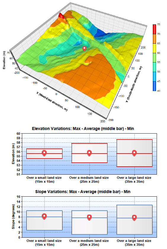
Besides the provision of spot elevation and slope for the address point, we create metric value ranges (min, average and max) in relation to three possible land sizes of residential blocks (Figure 1):
-
Small land size (15m x 15m)
-
Medium land size (25m x 25m)
-
Large land size (35m x 35m)

Figure 1: Contextual location information – elevation and slope
(Elevation data source: GA)
1.2 Vegetation
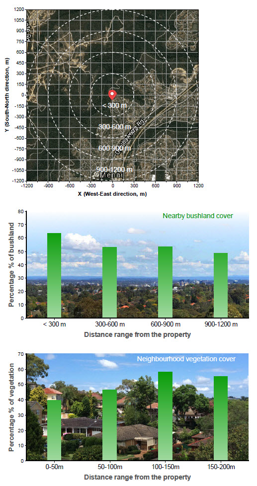
When quantifying vegetation amount for a specific location, vegetation densities at two scales are estimated (Figure 2):
-
At a broad level, metrics on nearby bushland cover
-
At a property level, metrics on neighbourhood vegetation cover

Figure 2: Contextual location information – vegetation cover
2. Creating Accessible Property Location Profile Reports
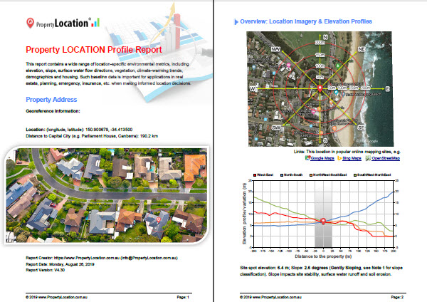
Address-level property location information databases containing many metrics are usually produced and shared in several SQL database formats. This facilitates enterprise-level analysis. We go beyond this by also producing accessible Property Location Profile Report for each G-NAF address (in PDF format, Figure 3).
The report contains a wide range of easy-to-understand location metrics, images, maps, charts, etc. Readily generating formatted documents with many visuals (say in the form of multi-page PDF report) is important for geospatial applications, a feature that has been lacking in today’s desktop and web mapping software.
Dozens of sample reports (25-page PDFs) are available at product websites (e.g. link 1, link 2).
Or, direct sample reports: Sample 1 | Sample 2 | Sample 3 | Sample 4 | Sample 5
If you’d like to acquire Property Location Profile Reports (Version 4.3, 25-page PDF) for your addresses of interest, please let us know and we are happy to generate complimentary reports for you.

Figure 3: Property Location Profile Report in PDF
3. Batch Processing for Bulk Data and Reports
Batch processing workflow is developed to analyse millions of G-NAF address points. Bulk outputs are in two forms:
-
Large-sized csv file or SQL database
-
Complementary PDF reports
For each address record, a PDF report is simultaneously generated. End users may find PDF reports very handy when sharing and checking out all contextual location information specific to an individual address.
In our approach, underlying input layers are updated as needed so that outputs from processing can instantly reflect any changes made in inputs. In batch processing, we endeavour to apply automation and optimisation to achieve maximum efficiency possible. Various types of analysis (e.g. statistical, geospatial and artificial neural networks) are embedded when necessary.
4. On-demand Data Processing Service with Web APIs
If bulk data supply is not needed, users can resort to efficient on-demand processing service to request particular location information specific to an address location. On-the-fly analysis is enabled together with the cloud-based big data and analytics platform deployed. Location information in the following forms can be delivered by subscription-based Location Profile APIs:
-
Metrics
-
Images
-
Maps
-
Charts
-
Animations
-
Full multi-page PDF report
(Please refer to BigData Earth – Location Profile APIs Developer Portal for details.)
End users can readily integrate each component returned from the API call into their own desktop or web applications. By this way location information can be delivered and shared in a very cost-effective, dynamic way. For more information, please refer to product websites where we showcase a number of Web Apps with property location information (e.g. link 1, link 2).
5. Conclusion
In this blog, four address-level property location information products are reviewed in relation to the application of G-NAF database. Main features of our products include:
-
Contextual location information is important beyond site-level metrics;
-
Multi-page Property Location Profile Report containing contextual location information is complementary to the output in SQL database form;
-
Batch processing is implemented to produce bulk outputs in two forms (SQL database and PDF report); and
-
On-demand data processing service is enabled via Web APIs.
