24 11, 2020

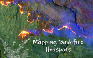
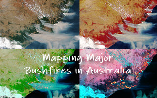
Mapping Major Bushfires in Australia using Near Real-time Himawari-8 Satellite Imagery

2022-08-08T08:15:39+10:00November 24th, 2020|AI, APIs, Apps, Asset Management, Australia, Bushfire, Climate Change, Cloud Computing, Earth Observation, Emergency, Geospatial Big Data Analytics, Image Analysis, Location Intelligence, Major Events, Risk|

Acknowledgements: This project is made possible thanks to the availability of Himawari-8 satellite imagery from the Japan Meteorological Agency (JMA, link) and its open access provided by AWS (link). Mapping bushfires using Earth observation (EO) imagery has been a very active research and application field. With a strong determination to [...]

24 11, 2020

Detecting Bushfire Hotspots from Himawari-8 Imagery: With Four Examples from the 2019-20 Australian Bushfire Season

2021-01-11T22:18:53+11:00November 24th, 2020|AI, APIs, Apps, Asset Management, Australia, Bushfire, Climate Change, Cloud Computing, Earth Observation, Emergency, Geospatial Big Data Analytics, Image Analysis, Location Intelligence, Major Events, News Media, Risk, Sentinel-2|

The new generation of geostationary meteorological satellites, such as Himawari-8 from the Japan Meteorological Agency (JMA, link), offer much improved capabilities of monitoring large-scale weather events in the atmosphere and phenomena on the Earth's surface. Himawari-8 sensors (Advanced Himawari Imagers - AHIs) are equipped with 16 spectral bands: 3 visible bands at 0.5 [...]

21 04, 2020

Four Property Location Information Products to Enrich G-NAF (Address Database) in Australia

2020-10-03T00:48:42+10:00April 21st, 2020|APIs, Apps, Asset Management, Australia, Elevation, Exposure, Geospatial Big Data Analytics, Insurance, Location Intelligence, Property Information, Real Estate, Risk|

21 April 2020 Geocoded National Address File (G-NAF) is Australia’s authoritative, geocoded address database. It contains more than 14 million physical address records (e.g. residential, commercial and industrial), each having spatially-explicit geocodes such as latitude/longitude coordinates. G-NAF, developed by PSMA Australia, has been available since 2004. A public version, Open G-NAF, has become [...]

22 02, 2019

The February 2019 Tropical Cyclone Oma, Australia

2021-04-16T15:03:29+10:00February 22nd, 2019|Apps, Asset Management, Australia, Earth Observation, Emergency, Exposure, Geospatial Big Data Analytics, Insurance, Location Intelligence, Major Events, Risk, Tropical Cyclone|

22 February 2019 It's good news that tropical cyclone Oma has weakened and remains offshore. Here we perform some quick analysis using the web APIs & Apps recently developed, and share results with the public (see Twitter posts below). 1. Overview of Current Exposure Why are we so concerned about this event? [...]

11 02, 2019

Some Exposure Analysis in Relation to the February 2019 Flooding in West & North-West Queensland

2020-12-11T15:03:34+11:00February 11th, 2019|Apps, Asset Management, Australia, Earth Observation, Emergency, Exposure, Flood, Geospatial Big Data Analytics, Image Analysis, Insurance, Location Intelligence, Major Events, Property Information, Risk|

11 February 2019 We have been active in reporting and sharing information about the major flooding in Queensland (link to Twitter posts and mass media mentions, e.g. CNN and The Guardian). This brief blog is specific to the flooding in West and North-West Queensland. First, the big picture. We use NASA’s Terra/MODIS imagery (2019-01-02 vs. [...]

28 01, 2019

Releasing a New Web Mapping, Analysis and Reporting App on Exposure Management

2020-10-03T00:49:11+10:00January 28th, 2019|APIs, Apps, Asia, Asset Management, Australia, Bushfire, Emergency, Exposure, Flood, Geospatial Big Data Analytics, Insurance, Location Intelligence, Major Events, Property Information, Risk, USA|

28 January 2019 Over the past few years we have been building cloud-based big data and analytics platforms and foundational Location Profile APIs for property location and hazard risk information. These advances have enabled us to speed up the pace of new product development. Now we are pleased to release a new web [...]

31 08, 2018

Location Profile APIs Out of Beta

2020-10-03T00:49:20+10:00August 31st, 2018|APIs, Asia, Asset Management, Exposure, Geospatial Big Data Analytics, Insurance, Location Intelligence, Property Information, Real Estate, Risk|

31 August 2018 We are pleased to release property/exposure Location Profile APIs (Version 2.0), out of beta! (Link to an initial release and introduction is here.) More than ten APIs are currently available for property location and hazard risk intelligence. Main applications: Property location information, emergency planning and response, insurance underwriting and claims, news media [...]

18 06, 2018

New Methods and Tools (Web APIs) for Innovative Exposure Analytics

2021-01-13T12:58:39+11:00June 18th, 2018|APIs, Asia, Asset Management, Australia, Exposure, Geospatial Big Data Analytics, Insurance, Location Intelligence, Major Events, Risk|

18 June 2018 Almost every industry has some types of exposure data, and its data quality and analysis are crucial for overall exposure management and decision making. For the businesses dealing with environmental, industrial, technological and man-made hazards and risk, the spatial and temporal accuracy of the underlying exposure data is among the most important. [...]

8 06, 2018

Introducing Location Profile APIs for Property Location and Hazard Risk Intelligence

2020-10-03T00:49:23+10:00June 8th, 2018|APIs, Asia, Asset Management, Australia, Exposure, Geospatial Big Data Analytics, Insurance, Location Intelligence, Property Information, Real Estate, Risk, USA|

8 June 2018 The public release of BigData Earth's Location Profile APIs is a milestone in our vision of achieving API-first, cloud-based big data analytics and innovative solutions. [Update 31 August 2018: APIs Version 2.0 out of beta] The set of APIs released now reflects our substantial R&D in the following major applications over [...]

9 03, 2017

PropertyLocation.com.au: Making Property (Exposure) Location Profile Reports for Australian Addresses on the Cloud

2020-10-03T00:49:48+10:00March 9th, 2017|Asset Management, Australia, Earth Observation, Image Analysis, Location Intelligence, Property Information, Real Estate|

9 March 2017 BigData Earth is pleased to release https://www.PropertyLocation.com.au/, a new web portal where consumers and professionals can quickly request property (exposure) location profile reports for Australian addresses and sites. Location, location, location - For industries such as real estate, asset management and insurance underwriting, the location information is among the most [...]

Go to Top