3. Coverage
Current Location Profile APIs cover three regions: Australia, the Contiguous US and the rest of the world, with varying levels of details in underlying data. Related API endpoints are in the forms below:
https://api.bigdataearth.com/au/location-analytics/{query string} – sample outputs
https://api.bigdataearth.com/us/location-analytics/{query string} – sample outputs
https://api.bigdataearth.com/ww/location-analytics/{query string} – sample outputs
Each of the above API endpoints returns an integrated location profile report. We also make theme-based APIs returning more specific results:
https://api.bigdataearth.com/au/bushfire-analytics/{query string}
https://api.bigdataearth.com/au/flood-analytics/{query string}
https://api.bigdataearth.com/au/exposure-analytics/{query string}
https://api.bigdataearth.com/us/vegetation-analytics/{query string}
https://api.bigdataearth.com/us/flood-analytics/{query string}
https://api.bigdataearth.com/ww/elevation-analytics/{query string}
https://api.bigdataearth.com/ww/exposure-analytics/{query string}
Our APIs have access to a number of open authoritative datasets from government agencies, including Geoscience Australia and the USGS. We often add pre-processing and critical evaluation to make sure the dataset is suitable for intended applications. The data sources analysed are acknowledged in the output of each API product.
As our API workflow is generic, it is flexible to rapidly digest other finer-resolution, domain-specific datasets (e.g. LiDAR-based DEM for flood modelling, hazards data for risk analytics, and company exposure data for asset management).
Our backend servers and data analytics engines are resided in and powered by Google Cloud Platform.
4. Examples
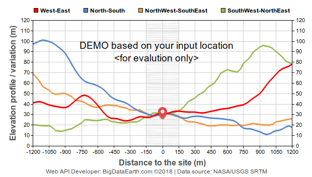
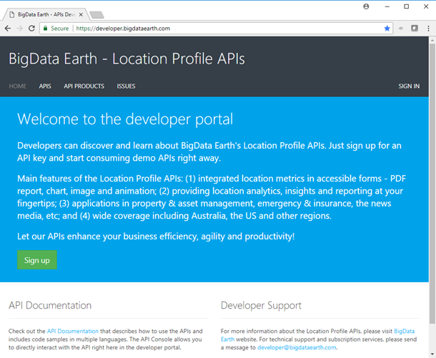
The developer portal shows code samples in different languages (e.g. Curl, JavaScript, Python and PHP) for application and system developers. Here we demonstrate an application of drawing elevation profiles at four directions for a location point around the world (Figure 4).
Figure 4: Typical elevation profile chart from a demo elevation analytics API
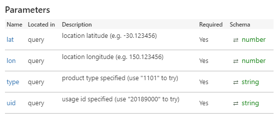
The use of API usually requires a unique API key (containing both key name and value) for validation and secure data access. The API key name could be varied (e.g. apikey, x-api-key, or cp-Apim-Subscription-Key). API key is often put in HTTP request Headers, but sometimes in the request string up to certain setups.
We encourage interested users to explore the developer portal and test APIs. Access key is automatically assigned after sign-in and product subscription. For the demo API, approval is not needed.
If not for web applications, the above access methods can also be used to download products for local uses, even with a batch mode. This might be handy for some users. (Mapping-based interfaces have been provided at our PropertyLocation.com.au and PropertyLocation360.com portals.)
5. Applications
APIs, to some degree like software command lines, can be easily deployed and integrated with your system, so you can help present relevant location metrics at your client’s fingertips. Our Location Profile APIs might benefit a number of location-centric applications, including:
-
Real estate and property search portals
-
Property information and valuation systems
-
Emergency response mapping portals
-
Insurance exposure information systems
-
Catastrophe loss modelling platforms
-
GIS and Earth observation image mapping portals
Our APIs can be complementary to the tools and functions your system is already providing. A developer can resort to third-party APIs to automate and deliver certain on-demand tasks to accelerate application development and gain competitive edge.
A common application scenario is that a client provides our APIs with known geocoded location and requests a location profile report, which will be accessible near real time or in seconds. So your client can get even more location intelligence before making informed location decisions. Customisation can be facilitated to create white-label reports for various application needs and scenarios.
The use of APIs is a paradigm shift in application development. It raises a question on whether to build in-house or get access to a particular set of data and functions from a third party via APIs. (Next blog will demonstrate the use of our exposure analytics APIs for exposure estimation worldwide.)


