27 05, 2016

Observing the May 2016 Fort McMurray Wildfire: A Survey of Satellite Imagery Sources (including Sentinel-2)

2020-10-03T00:50:02+10:00May 27th, 2016|Canada, Earth Observation, Image Analysis, Landsat, Major Events, Sentinel-2, Wildfire|

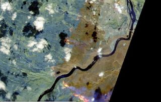
The May 2016 Fort McMurray Wildfire in Alberta, Canada is catastrophic. The fire started on May 1, and as of May 24, is still raging. The fire has destroyed ~2,400 homes and buildings, and resulted in massive fire scars (burnt areas) over 500,000 hectares. It becomes the most expensive nature disaster in Canadian history, with an [...]

1 04, 2016

Innovative Earth Observation Image Analysis for Wildfires and Flooding: Two U.S. Examples

2020-10-03T00:50:04+10:00April 1st, 2016|Bushfire, Earth Observation, Flood, Image Analysis, Landsat, Major Events, USA, Wildfire|

Modern Earth Observation satellites are often equipped with special sensors that are capable of measuring the reflectance of ground features at short-wave infrared (SWIR) wavelengths. Most SWIR images currently in use are from the following four major satellites: Sentinel-2 (ESA, 20m resolution for SWIR bands) Landsat-8 and Landsat-7 (NASA & USGS, 30m resolution for SWIR bands) ASTER [...]

8 03, 2016

Major Bushfires in Australia in 2015-2016 Summer: Before and After Satellite Imagery

2020-10-03T00:50:05+10:00March 8th, 2016|Australia, Bushfire, Climate Change, Earth Observation, Image Analysis, Landsat, Major Events, Wildfire|

8 March 2016 (We thank the Australian Broadcasting Corporation - ABC - for promoting this for the general public. Twitter, ABC website) Extreme temperatures, frequent heatwaves and prolonged drought (link), enhanced by one of the most powerful El Niño events, have once again caused many bushfires in Australia in 2015-2016 summer season. Major damaging bushfires (grass fires and forest fires) [...]

Go to Top