29 07, 2020

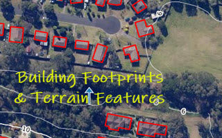
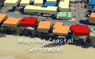
Mapping the Coastal Settlement in Wamberal, NSW: Two Approaches

2020-10-03T00:48:34+10:00July 29th, 2020|AI, Australia, Cloud Computing, Earth Observation, Elevation, Exposure, Flood, Geocoding, Geospatial Big Data Analytics, Image Analysis, Land parcel, Location Intelligence, Property Information, Risk|

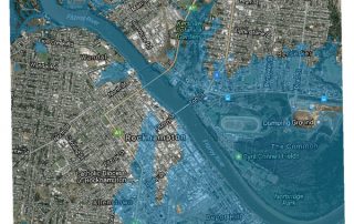
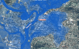
Quite a few coastal properties in Wamberal (NSW) are at risk of constant coastal erosion. This is again heightened by the threat from two Australian East Coast Lows affecting the NSW coast in recent few weeks. Two independent approaches, together with high-resolution public data sources, can be used to map the coastal settlement. [...]

21 07, 2020

Creating Building Footprints and Terrain Features for Web and Desktop Mapping: With Examples from the NSW Coast

2021-04-30T10:22:52+10:00July 21st, 2020|AI, Australia, Cloud Computing, Earth Observation, Elevation, Exposure, Flood, Geocoding, Geospatial Big Data Analytics, Image Analysis, Land parcel, Location Intelligence, Property Information, Risk|

High-resolution digital imagery (satellite, aerial or drone-based) and high-resolution elevation data (typically derived from LiDAR point clouds) are increasingly used in local and regional environmental studies. But it is still challenging to extract high-resolution feature attributes (e.g. building footprints from imagery and terrain metrics from digital elevation models) for deeper geospatial analysis and [...]

21 04, 2020

Four Property Location Information Products to Enrich G-NAF (Address Database) in Australia

2020-10-03T00:48:42+10:00April 21st, 2020|APIs, Apps, Asset Management, Australia, Elevation, Exposure, Geospatial Big Data Analytics, Insurance, Location Intelligence, Property Information, Real Estate, Risk|

21 April 2020 Geocoded National Address File (G-NAF) is Australia’s authoritative, geocoded address database. It contains more than 14 million physical address records (e.g. residential, commercial and industrial), each having spatially-explicit geocodes such as latitude/longitude coordinates. G-NAF, developed by PSMA Australia, has been available since 2004. A public version, Open G-NAF, has become [...]

2 10, 2018

Advancing Bushfire Risk Analytics with Location Profile APIs: Showcases

2021-01-10T13:37:21+11:00October 2nd, 2018|APIs, Australia, Bushfire, Elevation, Emergency, Exposure, Insurance, Location Intelligence, Property Information, Risk, USA|

2 October 2018 Bushfire (wildfire or forest fire) risk assessment has been a very common topic in research and practice. Many risk analysis projects, such as identifying likely causes of fire occurrences, mapping fire-prone areas and assessing Bushfire Attack Level (BAL) for buildings, are in place to assist the whole process of bushfire risk [...]

25 09, 2018

Advancing Flood Risk Analytics with Location Profile APIs: Showcases

2021-01-13T12:19:35+11:00September 25th, 2018|APIs, Asia, Australia, Elevation, Emergency, Exposure, Flood, Insurance, Location Intelligence, Property Information, Risk, USA|

25 September 2018 For flood risk assessment, one may develop flood hazard maps directly or just use existing maps which are often associated with modelled hazard return periods. The quality of each flood map is up to a range of factors, such as the quality of elevation and rainfall inputs, modelling methods, and [...]

12 03, 2018

The March 2018 Major Flooding in North Queensland, Australia

2020-10-03T00:49:23+10:00March 12th, 2018|Australia, Earth Observation, Elevation, Emergency, Flood, Insurance, Location Intelligence, Major Events, Risk|

12 March 2018 Devastating flooding once again took place in the North Queensland region. The Bureau of Meteorology had issued major flood warnings for quite a few river catchments, including: Herbert River Murray River Tully River Johnstone River Russell River Mulgrave River Among the regional cities and towns affected, Ingham has suffered the most damage as [...]

8 12, 2017

A Survey and Clarification of DEM Vertical Accuracy

2021-01-10T13:31:47+11:00December 8th, 2017|Earth Observation, Elevation, Flood, Location Intelligence, Risk, USA|

8 December 2017 For flood hazard modelling and risk analysis, Digital Elevation Model (DEM) is indispensable. Probably the most important metric about DEM quality is its vertical accuracy. Unfortunately, it is often confusing in literature and among various data offerings, and there are serious implications for applications, e.g. whether flood hazard rating can be confidently quantified [...]

21 11, 2017

Introducing Three New Tools for Investigating Flood-prone Areas in the U.S. and Australia

2020-10-03T00:49:23+10:00November 21st, 2017|Australia, Elevation, Flood, Location Intelligence, Property Information, Risk, USA|

21 November 2017 Flood mapping for large areas (e.g. from catchments to a national level) is relatively new and challenging; associating mapped flood-prone areas with an annual chance of occurrence (in probabilities, say 1%) of a flood event involves many kinds of uncertainties and is even harder. Flood maps that suggest various hazard levels over [...]

3 04, 2017

Visualising Low-lying Areas in Response to Major Flooding: Case Studies in Rockhampton and Bundaberg, Queensland

2021-01-13T11:54:25+11:00April 3rd, 2017|Australia, Earth Observation, Elevation, Flood, Location Intelligence, Major Events, Risk|

3 April 2017 Last Friday we developed two animations that show estimated flood extents of the major floods in Lismore and Murwillumbah, northern NSW. Today we extend that work and apply the same technique to effectively map and visualise many low-lying, flood-prone areas in Queensland. We choose the following two areas for demonstration: Rockhampton [...]

31 03, 2017

Rapidly Estimating the Flood Extent of Major Floods in Lismore and Murwillumbah on 31 March 2017: Animated Maps Included

2021-01-13T00:47:09+11:00March 31st, 2017|Australia, Earth Observation, Elevation, Flood, Location Intelligence, Major Events, Risk|

Initial release: 31 March 2017 The south-east QLD and northern NSW are often afflicted with widespread flooding caused by the torrential rain typically associated with ex-cyclones, and this time with the remnants of severe Tropical Cyclone Debbie which made landfall on the QLD coast between Bowen and Mackay on 28 March 2017.  Based on [...]

Go to Top