Products and Services
We offer end-to-end solutions for new products development, from datasets to modelling to web services (e.g. web Apps, APIs and Maps). We go beyond common imagery and basemaps, and strive to deliver integrated information products with unique location metrics and insights on the environment, property location and hazard risk.
A range of information products have been developed at scale with significant use of automation and optimisation. Cloud-based big data and analytics platforms, e.g. PropertyLocation.com.au and PropertyLocation360.com, are in use for the efficient delivery of outputs via web Apps, web APIs, downloads, emails, etc. Since 2018, two website aliases – RiskMapping.com.au and GeoRisk360.com – have been used to deliver products in relation to hazard risk.
Meanwhile, we collaborate with businesses who have massive geospatial datasets (e.g. gigabytes or terabytes in file sizes) and are also keen to create innovative location-centric applications. We believe that partnership, understanding, critical analysis, imagination and hard work will result in unique and cost-effective solutions to the industry. Let’s explore new directions and be one step ahead of the crowd.
Example Products and Services

Earth Observation, Image Processing and Feature Extraction
A vast amount of imagery is being acquired by modern Earth Observation sensors every day. The real challenge is to analyse the raw imagery quickly and extract useful, actionable information with higher accuracy for practical applications. We develop accessible image analysis software and batch processing workflows, and make a contribution to this direction. Our latest effort is to develop dedicated software tools to rapidly process daily fresh imagery (including Copernicus/ESA Sentinel-2, NASA/USGS Landsat-8, JMA Himawari 8/9 and NOAA GOES 16/17), and apply new artificial intelligence and deep learning techniques for image feature extraction.

Building-level Geocoding of G-NAF (address database) for Improved Flood & Bushfire Risk Analysis in Australia
- Comparison between parcel-level and building-level geocoding
- Geocoding differences in the context of flood and bushfire risk analysis
- Building-level geocoding of G-NAF address points for most flood- and bushfire-prone regions in Australia

Integrated Cloud-based Geospatial Processing Services (with Web API, Web App and Web Mapping)
We have recently developed a suite of cloud-based processing technologies and workflows that can quickly turn your usual DEMs into modern tile maps (on terrain and hydrology), which can then be readily consumed by web and desktop GIS mapping.
High-resolution tile maps on terrain and hydrology include:
- Elevation contours
- Modelled surface water flow directions
- Shaded relief
Australian tile maps on offer (link)

Two Additional Tools to Advance Flood Risk Analytics at Scale in Australia
We have been active developing site-level flood risk analytics tools, e.g.
- Introducing Three New Tools for Investigating Flood-prone Areas (11/2017)
- Advancing Flood Risk Analytics with Location Profile APIs (09/2018)
Now we are pleased to release two additional new tools as part of our ongoing significant effort to improve the accuracy, transparency and accessibility of underling hazard risk information.

New Web Mapping, Analysis and Reporting App on Exposure Management
Over the past few years we have been building cloud-based big data and analytics platforms and foundational Location Profile APIs for property location and hazard risk information. These advances have enabled us to speed up the pace of new product development. Now we are pleased to release a new web App on location-centric exposure management specific to emergency and insurance applications. The new App combines web mapping, analysis and reporting together. [News Release]

Location Profile APIs for Property Location and Hazard Risk Intelligence
We have been creating a series of unique Location Profile APIs, including:

New-generation Property / Exposure Location Information:
From Earth Observation to Metrics & Insights Report
For applications in real estate, asset management, emergency, insurance, the news media, etc., the location information of properties (e.g. residential, commercial and industrial buildings) is among the most important. Through deep research and development, we create new-generation property / exposure location information and insights by integrating various thematic layers (including terrain, land cover, climate change, and natural hazard risk) from a single dimension to 2D/3D/4D and across geographic scales. Detailed property location profiles for addresses in Australia and the U.S., and broad-level property location profiles for worldwide sites are being developed and offered, via (1) PropertyLocation.com.au, (2) PropertyLocation360.com, and (3) Location Profile APIs.
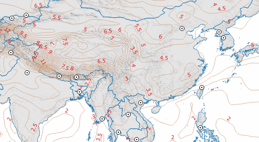
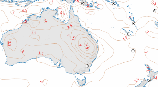
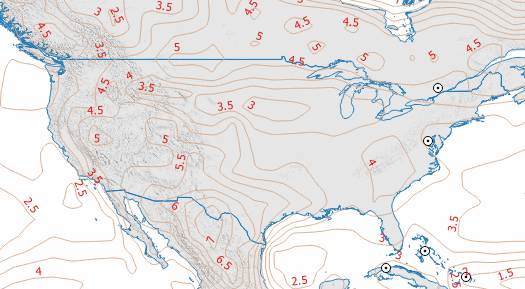
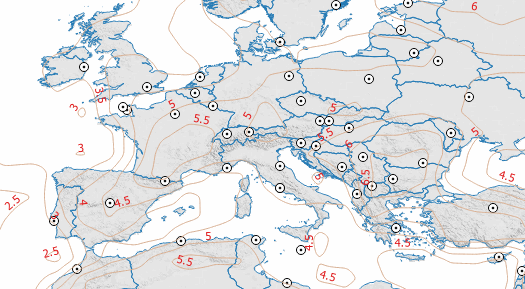
Dangerous global warming trend. The increase of average daily maximum surface temperature (by year, in degrees Celsius) from 1950 (historical, hindcast) to 2100 (projected) across regions, based on the NOAA Geophysical Fluid Dynamics Laboratory Climate Model V3 (GFDL-CM3) under a moderate greenhouse gas emissions scenario known as Representative Concentration Pathway – RCP 4.5. Original data source: NASA Earth Exchange Global Daily Downscaled Projections (NEX-GDDP, 2015).
Global Warming & Climate Change Impacts
We help the scientific community and government agencies communicate this important message to the general public. How will the current anthropogenic global warming (IPCC Fifth Assessment Report, 2014) observed at an unprecedented rate impact your location, your assets and your plans in the future?
Climate change is having significant impacts on our environment, society and economy; population, settlements and infrastructure are increasingly at risk. The impact varies by region and over time. We assemble the latest scientific information, develop accessible communication tools, and then share with those who are concerned about the potential negative impact of climate change.
Automated routines have been developed to process and analyse the large-sized NASA Earth Exchange Global Daily Downscaled Projections dataset (NEX-GDDP, 2015; ~12TB). The result in the form of maps and graphs may be more accessible to the general public, and an example is shown at the left side. Interested users can download warming trend reports (PDF files) for 559 Local Government Areas in Australia and 222 national capitals of the world using the link below.

Three New Tools for Investigating Flood-prone Areas in the United States and Australia
There is a real need to create new, insightful information products that can be used to proactively investigate flood-prone areas across a whole range of scales – from sites to river basins to a national level. Elevation is the single most important variable in determining flood hazard levels, and we focus on this by developing three flood analysis tools. Each can be implemented at scale and is a significant undertaking. We hope these tools can provide more geographic context and shed light on some key hydrodynamic processes about flooding.

High-resolution Vegetation Mapping for
48 Contiguous U.S. States
13 June 2016: We have sourced the comprehensive, orthorectified digital aerial imagery from the USDA National Agriculture Imagery Program (NAIP) and performed advanced imagery feature extraction. The most recent NAIP imagery at 1m-resolution acquired in 2015, 2014 and 2013 growing seasons, involving ~180 terabytes of uncompressed raw data, has been analyzed. To our knowledge, this is the first time that large-scale vegetation mapping is done at such a detailed level. [News Release]


3D terrain texture is embedded in common 2D world imagery basemaps. Left: Enhanced imagery showing terrain texture; Right: Original 2D imagery. Location: Koblenz, Germany.
Global Imagery Basemaps with 3D Terrain Texture
Carefully-processed generic basemaps (e.g. street and 2D imagery) are handy and great, but enhanced imagery basemaps related to specific disciplinary fields, such as climate risk, natural hazards, agriculture and mining, are always in short supply.
Many terabytes of Landsat-7 and Landsat-8 satellite imagery from the NASA and USGS Landsat program, and Sentinel-2 satellite imagery from the Copernicus EO program and ESA, have been used to make enhanced imagery basemaps at 30m, 15m and 10m resolutions. For example, important 3D terrain features are embedded in common 2D imagery so the basemap becomes more insightful, context rich and visually appealing. Such enhanced basemaps are very effective communication tools in many environmental studies.


For some SRTM raw data with voids (gaps), an important step in post-processing is to fill the gaps with varying techniques. Left: 30m-resolution SRTM data with gaps from Source 1; Right: 30m-resolution SRTM data with gaps filled from Source 2. Location: PNG.
Global Elevation Data Evaluation & Basemaps
A few global / near-global elevation data sets (each at 1-arc-second or 30m resolution) are freely available: (1) SRTM v3 (full release finished in August 2015); (2) ASTER GDEM v2.; and (3) AW3D v2.
Such data sets are widely used by the scientific community. Now there are many downloadable versions in the public domain, but how good each version is for specific modelling and applications (e.g. flood modelling)? Does the data quality vary significantly across regions and among versions? The data quality of such inputs is critical to modelling and modelled results, and we provide detailed evaluation and practical advice.