18 09, 2019

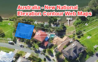
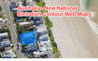
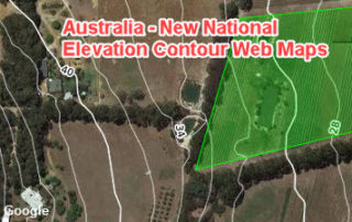
New Tile Maps on Terrain and Hydrology: Part 1 (Enriching Google Maps)

2020-10-16T00:28:14+11:00September 18th, 2019|APIs, Apps, Australia, Emergency, Exposure, Flood, Geospatial Big Data Analytics, Insurance, Location Intelligence, Property Information, Risk|

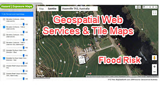
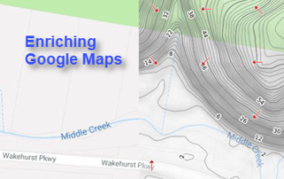
18 September 2019 Google Maps is very popular and easy to use, and many of us would have imagined creating and delivering domain-specific mapping layers in the same or similar way Google Maps does. To realise this, we have recently created and released a set of new, high-resolution tiled web maps (or tile [...]

12 08, 2019

New R&D in Property Location and Hazard Risk Analytics: A Transformative Journey from Desktop Computing to Cloud Computing

2021-03-08T14:10:46+11:00August 12th, 2019|APIs, Apps, Asia, Australia, Emergency, Exposure, Flood, Geospatial Big Data Analytics, Insurance, Location Intelligence, Property Information, Risk, USA|

12 August 2019 Over the past four years we have been undertaking significant new R&D in property location and hazard risk analytics with cloud computing. In particular, we have developed an organic set of products based on three new technologies (Web APIs, Web Apps and Web Maps) to support two cloud-based geospatial [...]

18 06, 2019

Applications of New National Contour Web Maps: Part 3 (Identifying Riverine Flood-prone Areas)

2020-10-03T00:49:05+10:00June 18th, 2019|APIs, Apps, Australia, Emergency, Exposure, Flood, Geospatial Big Data Analytics, Insurance, Location Intelligence, Property Information, Risk|

18 June 2019 We keep showcasing the potential application of new high-resolution contour web maps for Australia that have been recently developed (link). Previous blogs in this series include: Applications of New National Contour Web Maps: Part 2 (Identifying Low-lying Coastal Areas) - link Applications of New National Contour Web Maps: Part [...]

3 06, 2019

Applications of New National Contour Web Maps: Part 2 (Identifying Low-lying Coastal Areas)

2020-10-03T00:49:07+10:00June 3rd, 2019|APIs, Apps, Australia, Emergency, Exposure, Flood, Geospatial Big Data Analytics, Insurance, Location Intelligence, Property Information, Risk|

3 June 2019 We keep demonstrating the potential use of new national contour web maps that have been developed in a recent flood risk analytics project (link). Previous blogs in this series include: Applications of New National Contour Web Maps: Part 1 (Enhancing High-resolution Imagery Mapping) - link In this blog we [...]

30 05, 2019

Applications of New National Contour Web Maps: Part 1 (Enhancing High-resolution Imagery Mapping)

2020-10-03T00:49:08+10:00May 30th, 2019|APIs, Apps, Australia, Emergency, Exposure, Flood, Geospatial Big Data Analytics, Insurance, Location Intelligence, Property Information, Risk|

30 May 2019 In the previous blog, we reported a national flood risk analytics project that has produced a set of high-resolution tiled web maps on elevation contextual layers and terrain metrics, including contours, modelled surface water flow directions and shaded relief. These web maps are also complementary to desktop, web or mobile [...]

22 05, 2019

Two Additional Tools to Advance Flood Risk Analytics at Scale in Australia

2021-01-29T13:10:18+11:00May 22nd, 2019|APIs, Apps, Australia, Emergency, Exposure, Flood, Geospatial Big Data Analytics, Insurance, Location Intelligence, Property Information, Risk|

Initial release: 22 May 2019 Over the past few years we have been active developing site-level flood risk analytics tools, e.g. - Introducing Three New Tools for Investigating Flood-prone Areas (link, 11/2017) - Advancing Flood Risk Analytics with Location Profile APIs (link, 09/2018) Now we are pleased to release two additional new [...]

11 02, 2019

Some Exposure Analysis in Relation to the February 2019 Flooding in West & North-West Queensland

2020-12-11T15:03:34+11:00February 11th, 2019|Apps, Asset Management, Australia, Earth Observation, Emergency, Exposure, Flood, Geospatial Big Data Analytics, Image Analysis, Insurance, Location Intelligence, Major Events, Property Information, Risk|

11 February 2019 We have been active in reporting and sharing information about the major flooding in Queensland (link to Twitter posts and mass media mentions, e.g. CNN and The Guardian). This brief blog is specific to the flooding in West and North-West Queensland. First, the big picture. We use NASA’s Terra/MODIS imagery (2019-01-02 vs. [...]

28 01, 2019

Releasing a New Web Mapping, Analysis and Reporting App on Exposure Management

2020-10-03T00:49:11+10:00January 28th, 2019|APIs, Apps, Asia, Asset Management, Australia, Bushfire, Emergency, Exposure, Flood, Geospatial Big Data Analytics, Insurance, Location Intelligence, Major Events, Property Information, Risk, USA|

28 January 2019 Over the past few years we have been building cloud-based big data and analytics platforms and foundational Location Profile APIs for property location and hazard risk information. These advances have enabled us to speed up the pace of new product development. Now we are pleased to release a new web [...]

12 12, 2018

Reducing Uncertainties in Catastrophe Loss Modelling: New Advances

2021-01-13T13:08:02+11:00December 12th, 2018|APIs, Asia, Australia, Bushfire, Earth Observation, Exposure, Geospatial Big Data Analytics, Hurricane, Insurance, Location Intelligence, Property Information, Risk, Tropical Cyclone, USA|

12 December 2018 This is our 2018 end-of-year review article. Catastrophe loss modelling, as a special type of environmental modelling, has been around for three decades. It captures all essential components of the classic risk equation, i.e. Risk = f (Hazard, Exposure, Vulnerability), and quantifies the likely economic or insured losses arising [...]

2 10, 2018

Advancing Bushfire Risk Analytics with Location Profile APIs: Showcases

2021-01-10T13:37:21+11:00October 2nd, 2018|APIs, Australia, Bushfire, Elevation, Emergency, Exposure, Insurance, Location Intelligence, Property Information, Risk, USA|

2 October 2018 Bushfire (wildfire or forest fire) risk assessment has been a very common topic in research and practice. Many risk analysis projects, such as identifying likely causes of fire occurrences, mapping fire-prone areas and assessing Bushfire Attack Level (BAL) for buildings, are in place to assist the whole process of bushfire risk [...]

Go to Top