16 10, 2017

Some Imagery Sources for the Northern California Wildfires in October 2017

2020-10-03T00:49:25+10:00October 16th, 2017|Earth Observation, Location Intelligence, Major Events, News Media, USA, Wildfire|

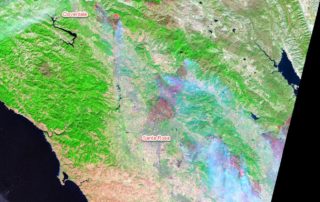
16 October 2017 The catastrophic wildfires in Northern California started a week ago have claimed at least 40 lives and destroyed nearly 6,000 buildings (news report). The fires continuously burning over the past week and the extensive damage have been observed by low-, medium- and high-resolution satellite imagery. Here we summarise and analyse a few useful imagery sources. [...]

28 08, 2017

News Release: BigData Earth Offers Cloud-based Rapid LOCATION Analytics For The News Media Worldwide

2021-01-13T13:13:00+11:00August 28th, 2017|Asia, Australia, Earth Observation, Location Intelligence, Major Events, News Media, Risk, USA|

Location information is critical for news reporting, especially in the event of emergencies, natural disasters, industrial pollution, etc. Relevant location information and insights can not only make the news story more detailed and interesting, but also help readers understand each event and its context more quickly. BigData Earth has been developing unique location [...]

10 08, 2017

New Study: Rapid Exposure Accumulation in Australia’s Coastal Region from 2006 to 2016

2020-10-03T00:49:30+10:00August 10th, 2017|Australia, Census, Exposure, Location Intelligence, Property Information|

10 August 2017 In the previous post, we presented the increase of Australian population and residential dwellings from 2006 to 2016, and how they vary across States and Territories. In this post, we report how much and how fast exposure has changed in coastal regions during the same period. (Australia is sometimes seen as the world’s largest [...]

10 08, 2017

Exposure Changes in Australia: Time Series Profiles of Population and Residential Dwellings from Censuses 2006, 2011 and 2016

2020-10-03T00:49:31+10:00August 10th, 2017|Australia, Census, Exposure, Location Intelligence, Property Information|

10 August 2017 The Australian Bureau of Statistics (ABS) has recently released the first batch of 2016 Census data, and its DataPacks can be obtained here. The new time series profiles on community characteristics provide a unique perspective on how Australian exposure has been changing over the past decade. In this post, we report population [...]

26 06, 2017

Developing Exposure LOCATION Profile for International News Reporting: Take the 2017-06-24 Landslide in SW China as an Example

2020-10-03T00:49:35+10:00June 26th, 2017|Asia, Earth Observation, Landslide, Location Intelligence, Major Events, Risk|

26 June 2017 Location information and insights are becoming ubiquitous and more important than ever. Tangible and easy-to-read location information, mainly through maps and various visualisation techniques, enhances our understanding of many dynamic phenomena. For the current news reporting on major hazardous events taking place around the world, there is a need to include more detailed and coherent [...]

3 04, 2017

Visualising Low-lying Areas in Response to Major Flooding: Case Studies in Rockhampton and Bundaberg, Queensland

2021-01-13T11:54:25+11:00April 3rd, 2017|Australia, Earth Observation, Elevation, Flood, Location Intelligence, Major Events, Risk|

3 April 2017 Last Friday we developed two animations that show estimated flood extents of the major floods in Lismore and Murwillumbah, northern NSW. Today we extend that work and apply the same technique to effectively map and visualise many low-lying, flood-prone areas in Queensland. We choose the following two areas for demonstration: Rockhampton [...]

31 03, 2017

Rapidly Estimating the Flood Extent of Major Floods in Lismore and Murwillumbah on 31 March 2017: Animated Maps Included

2021-01-13T00:47:09+11:00March 31st, 2017|Australia, Earth Observation, Elevation, Flood, Location Intelligence, Major Events, Risk|

Initial release: 31 March 2017 The south-east QLD and northern NSW are often afflicted with widespread flooding caused by the torrential rain typically associated with ex-cyclones, and this time with the remnants of severe Tropical Cyclone Debbie which made landfall on the QLD coast between Bowen and Mackay on 28 March 2017.  Based on [...]

27 03, 2017

The March 2017 Tropical Cyclone Debbie: Three Exposure Location Profile Reports for Sites in Townsville, Bowen and Mackay, Queensland

2021-04-16T14:55:53+10:00March 27th, 2017|Australia, Earth Observation, Location Intelligence, Major Events, Property Information|

27 March 2017 It is forecast that Tropical Cyclone Debbie will cause severe damage to the coastal region spanning from Townsville in the north to Mackay in the south. It will make landfall near Bowen. Figure 1: Latest track forecast for TC Debbie (Source: BoM) We use a newly-developed national platform to [...]

27 03, 2017

Developing Exposure Location Profile Report for Emergency and Insurance Applications: A National Platform

2020-10-03T00:49:45+10:00March 27th, 2017|Australia, Earth Observation, Image Analysis, Location Intelligence, Property Information, Real Estate|

27 March 2017 BigData Earth has been developing cloud-based solutions for delivering property (exposure) location profile reports, and one of these is for emergency and insurance applications (e.g. emergency planning and response, and insurance underwriting). For locations, addresses or sites in Australia, a national platform and web portal has been developed: https://propertylocation.com.au/georisk.html Main [...]

9 03, 2017

PropertyLocation.com.au: Making Property (Exposure) Location Profile Reports for Australian Addresses on the Cloud

2020-10-03T00:49:48+10:00March 9th, 2017|Asset Management, Australia, Earth Observation, Image Analysis, Location Intelligence, Property Information, Real Estate|

9 March 2017 BigData Earth is pleased to release https://www.PropertyLocation.com.au/, a new web portal where consumers and professionals can quickly request property (exposure) location profile reports for Australian addresses and sites. Location, location, location - For industries such as real estate, asset management and insurance underwriting, the location information is among the most [...]

Go to Top