5 12, 2016

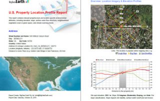
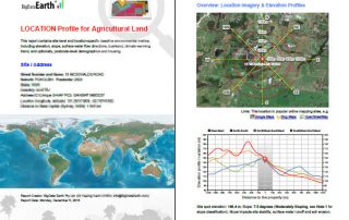
BigData Earth Develops New Location Profile Report for Worldwide Agricultural Land

2021-02-04T11:37:39+11:00December 5th, 2016|Agriculture, Asia, Asset Management, Australia, Climate Change, Cloud Computing, Earth Observation, Flood, Geospatial Big Data Analytics, Image Analysis, Location Intelligence, Property Information, USA|

Modern Earth observation technologies (spaceborne, airborne and terrestrial) are increasingly deployed to capture environmental attributes about agricultural land and assets. Geospatial big data collected by various sensors and the information extracted are critical for the growing AgTech and digital agriculture business. Many baseline terrain and environmental metrics for agricultural land should be systematically [...]

3 11, 2016

BigData Earth Develops New-generation Property Location Information for Addresses in the U.S. and Australia

2020-10-03T00:49:54+10:00November 3rd, 2016|Asset Management, Australia, Climate Change, Earth Observation, Elevation, Location Intelligence, Property Information, Real Estate, Risk, USA|

3 November 2016 For industries such as asset management, real estate and insurance underwriting, the location information of assets (e.g. buildings, infrastructure facilities, and agricultural land) is among the most important. Through deep research and development, BigData Earth creates new-generation property location metrics and insights by integrating various thematic layers (including terrain, land cover, climate change, natural [...]

Go to Top