31 08, 2018

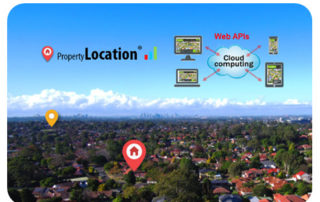
Location Profile APIs Out of Beta

2020-10-03T00:49:20+10:00August 31st, 2018|APIs, Asia, Asset Management, Exposure, Geospatial Big Data Analytics, Insurance, Location Intelligence, Property Information, Real Estate, Risk|

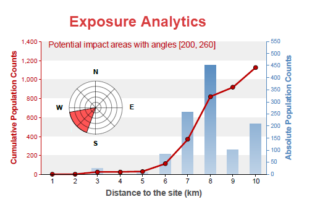
31 August 2018 We are pleased to release property/exposure Location Profile APIs (Version 2.0), out of beta! (Link to an initial release and introduction is here.) More than ten APIs are currently available for property location and hazard risk intelligence. Main applications: Property location information, emergency planning and response, insurance underwriting and claims, news media [...]

18 06, 2018

New Methods and Tools (Web APIs) for Innovative Exposure Analytics

2021-01-13T12:58:39+11:00June 18th, 2018|APIs, Asia, Asset Management, Australia, Exposure, Geospatial Big Data Analytics, Insurance, Location Intelligence, Major Events, Risk|

18 June 2018 Almost every industry has some types of exposure data, and its data quality and analysis are crucial for overall exposure management and decision making. For the businesses dealing with environmental, industrial, technological and man-made hazards and risk, the spatial and temporal accuracy of the underlying exposure data is among the most important. [...]

8 06, 2018

Introducing Location Profile APIs for Property Location and Hazard Risk Intelligence

2020-10-03T00:49:23+10:00June 8th, 2018|APIs, Asia, Asset Management, Australia, Exposure, Geospatial Big Data Analytics, Insurance, Location Intelligence, Property Information, Real Estate, Risk, USA|

8 June 2018 The public release of BigData Earth's Location Profile APIs is a milestone in our vision of achieving API-first, cloud-based big data analytics and innovative solutions. [Update 31 August 2018: APIs Version 2.0 out of beta] The set of APIs released now reflects our substantial R&D in the following major applications over [...]

Go to Top