3 06, 2019

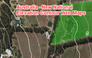
Applications of New National Contour Web Maps: Part 2 (Identifying Low-lying Coastal Areas)

2020-10-03T00:49:07+10:00June 3rd, 2019|APIs, Apps, Australia, Emergency, Exposure, Flood, Geospatial Big Data Analytics, Insurance, Location Intelligence, Property Information, Risk|

3 June 2019 We keep demonstrating the potential use of new national contour web maps that have been developed in a recent flood risk analytics project (link). Previous blogs in this series include: Applications of New National Contour Web Maps: Part 1 (Enhancing High-resolution Imagery Mapping) - link In this blog we [...]

30 05, 2019

Applications of New National Contour Web Maps: Part 1 (Enhancing High-resolution Imagery Mapping)

2020-10-03T00:49:08+10:00May 30th, 2019|APIs, Apps, Australia, Emergency, Exposure, Flood, Geospatial Big Data Analytics, Insurance, Location Intelligence, Property Information, Risk|

30 May 2019 In the previous blog, we reported a national flood risk analytics project that has produced a set of high-resolution tiled web maps on elevation contextual layers and terrain metrics, including contours, modelled surface water flow directions and shaded relief. These web maps are also complementary to desktop, web or mobile [...]

22 05, 2019

Two Additional Tools to Advance Flood Risk Analytics at Scale in Australia

2021-01-29T13:10:18+11:00May 22nd, 2019|APIs, Apps, Australia, Emergency, Exposure, Flood, Geospatial Big Data Analytics, Insurance, Location Intelligence, Property Information, Risk|

Initial release: 22 May 2019 Over the past few years we have been active developing site-level flood risk analytics tools, e.g. - Introducing Three New Tools for Investigating Flood-prone Areas (link, 11/2017) - Advancing Flood Risk Analytics with Location Profile APIs (link, 09/2018) Now we are pleased to release two additional new [...]

28 01, 2019

Releasing a New Web Mapping, Analysis and Reporting App on Exposure Management

2020-10-03T00:49:11+10:00January 28th, 2019|APIs, Apps, Asia, Asset Management, Australia, Bushfire, Emergency, Exposure, Flood, Geospatial Big Data Analytics, Insurance, Location Intelligence, Major Events, Property Information, Risk, USA|

28 January 2019 Over the past few years we have been building cloud-based big data and analytics platforms and foundational Location Profile APIs for property location and hazard risk information. These advances have enabled us to speed up the pace of new product development. Now we are pleased to release a new web [...]

12 12, 2018

Reducing Uncertainties in Catastrophe Loss Modelling: New Advances

2021-01-13T13:08:02+11:00December 12th, 2018|APIs, Asia, Australia, Bushfire, Earth Observation, Exposure, Geospatial Big Data Analytics, Hurricane, Insurance, Location Intelligence, Property Information, Risk, Tropical Cyclone, USA|

12 December 2018 This is our 2018 end-of-year review article. Catastrophe loss modelling, as a special type of environmental modelling, has been around for three decades. It captures all essential components of the classic risk equation, i.e. Risk = f (Hazard, Exposure, Vulnerability), and quantifies the likely economic or insured losses arising [...]

22 10, 2018

Advancing Tropical Cyclone Risk Analytics with Location Profile APIs

2021-03-08T14:08:28+11:00October 22nd, 2018|APIs, Asia, Australia, Emergency, Exposure, Hurricane, Insurance, Location Intelligence, Risk, Tropical Cyclone, Typhoon, USA|

22 October 2018 This project is focused on the analysis of historical tropical cyclones (also known as hurricanes or typhoons) and related wind records, including track positions, wind speed and central pressure. We have developed an automated process of carrying out such analyses on the cloud and enabled by web APIs. A straightforward [...]

2 10, 2018

Advancing Bushfire Risk Analytics with Location Profile APIs: Showcases

2021-01-10T13:37:21+11:00October 2nd, 2018|APIs, Australia, Bushfire, Elevation, Emergency, Exposure, Insurance, Location Intelligence, Property Information, Risk, USA|

2 October 2018 Bushfire (wildfire or forest fire) risk assessment has been a very common topic in research and practice. Many risk analysis projects, such as identifying likely causes of fire occurrences, mapping fire-prone areas and assessing Bushfire Attack Level (BAL) for buildings, are in place to assist the whole process of bushfire risk [...]

25 09, 2018

Advancing Flood Risk Analytics with Location Profile APIs: Showcases

2021-01-13T12:19:35+11:00September 25th, 2018|APIs, Asia, Australia, Elevation, Emergency, Exposure, Flood, Insurance, Location Intelligence, Property Information, Risk, USA|

25 September 2018 For flood risk assessment, one may develop flood hazard maps directly or just use existing maps which are often associated with modelled hazard return periods. The quality of each flood map is up to a range of factors, such as the quality of elevation and rainfall inputs, modelling methods, and [...]

21 09, 2018

The September 2018 Super Typhoon Mangkhut: Some Rapid Risk Analyses

2020-10-03T00:49:17+10:00September 21st, 2018|APIs, Asia, Earth Observation, Exposure, Flood, Hurricane, Image Analysis, Insurance, Location Intelligence, Major Events, Tropical Cyclone, Typhoon|

21 September 2018 Super Typhoon Mangkhut made landfall in Guangdong Province, China around 5 PM Sunday (16 September 2018) as a Category 2 hurricane (in Saffir–Simpson hurricane wind scale). This blog summarises a number of rapid analyses we performed and some of our existing information products that can be used to help assess the [...]

21 09, 2018

Assessing the Impact of the September 2018 Hurricane Florence

2020-10-03T00:49:17+10:00September 21st, 2018|APIs, Earth Observation, Exposure, Flood, Hurricane, Image Analysis, Insurance, Location Intelligence, Major Events, Tropical Cyclone, Typhoon, USA|

21 September 2018 Hurricane Florence made landfall near Wrightsville Beach, North Carolina at 7:15 AM on Friday (14 September 2018) as a Category 1 hurricane. This blog summarises some of our existing information products and new analytics that can be used to help assess the impact of this major event. 1. Location [...]

Go to Top