Blog

Home/Blog/
1 04, 2016

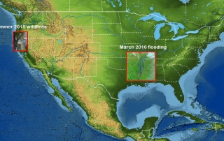
Innovative Earth Observation Image Analysis for Wildfires and Flooding: Two U.S. Examples

2020-10-03T00:50:04+10:00April 1st, 2016|Bushfire, Earth Observation, Flood, Image Analysis, Landsat, Major Events, USA, Wildfire|

Modern Earth Observation satellites are often equipped with special sensors that are capable of measuring the reflectance of ground features at short-wave infrared (SWIR) wavelengths. Most SWIR images currently in use are from the following four major satellites: Sentinel-2 (ESA, 20m resolution for SWIR bands) Landsat-8 and Landsat-7 (NASA & USGS, 30m resolution for SWIR bands) ASTER [...]

8 03, 2016

Major Bushfires in Australia in 2015-2016 Summer: Before and After Satellite Imagery

2020-10-03T00:50:05+10:00March 8th, 2016|Australia, Bushfire, Climate Change, Earth Observation, Image Analysis, Landsat, Major Events, Wildfire|

8 March 2016 (We thank the Australian Broadcasting Corporation - ABC - for promoting this for the general public. Twitter, ABC website) Extreme temperatures, frequent heatwaves and prolonged drought (link), enhanced by one of the most powerful El Niño events, have once again caused many bushfires in Australia in 2015-2016 summer season. Major damaging bushfires (grass fires and forest fires) [...]

5 03, 2016

The Warming Trend across Australia in 2100

2020-10-03T00:50:06+10:00March 5th, 2016|Australia, Climate Change|

Statements on the warming climate are supported by two main research approaches: observation and modelling. Observation: It has long been diagnosed that the Earth has a fever, and some latest measurements and facts are alarming: 2015 was the hottest on record globally; January 2016 was the hottest month on record globally (link); February 2016 had record warmth in [...]

3 03, 2016

Releasing 30m-resolution, Large-sized Global Elevation Mosaic and Shaded-relief Basemaps

2020-10-03T00:50:07+10:00March 3rd, 2016|Elevation|

Terrain data are extremely useful and essential for a wide range of environmental studies. At the local level, high-density LiDAR point clouds and derived high-resolution (e.g. 1m) Digital Elevation Models (DEMs) are increasingly produced. At the global level, medium-resolution (30m) open elevation data (e.g. SRTM and ASTER GDEM) are popular in the scientific community. The quality [...]

1 03, 2016

About Blog Posts

2020-10-03T00:50:08+10:00March 1st, 2016|Uncategorized|

1 March 2016: It's the first day of autumn today in Australia in the Southern Hemisphere! We have decided to make regular blog posts on this web portal describing some research interests and projects we are currently undertaking. Many aspects of our R&D activities and explorations - from data collection to applications development, from analysis tips [...]

Go to Top