Blog

Home/Blog/
27 03, 2017

Developing Exposure Location Profile Report for Emergency and Insurance Applications: A National Platform

2020-10-03T00:49:45+10:00March 27th, 2017|Australia, Earth Observation, Image Analysis, Location Intelligence, Property Information, Real Estate|

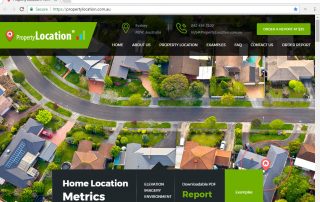
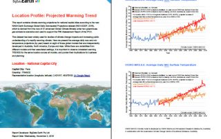
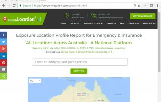
27 March 2017 BigData Earth has been developing cloud-based solutions for delivering property (exposure) location profile reports, and one of these is for emergency and insurance applications (e.g. emergency planning and response, and insurance underwriting). For locations, addresses or sites in Australia, a national platform and web portal has been developed: https://propertylocation.com.au/georisk.html Main [...]

9 03, 2017

PropertyLocation.com.au: Making Property (Exposure) Location Profile Reports for Australian Addresses on the Cloud

2020-10-03T00:49:48+10:00March 9th, 2017|Asset Management, Australia, Earth Observation, Image Analysis, Location Intelligence, Property Information, Real Estate|

9 March 2017 BigData Earth is pleased to release https://www.PropertyLocation.com.au/, a new web portal where consumers and professionals can quickly request property (exposure) location profile reports for Australian addresses and sites. Location, location, location - For industries such as real estate, asset management and insurance underwriting, the location information is among the most [...]

5 12, 2016

BigData Earth Develops New Location Profile Report for Worldwide Agricultural Land

2021-02-04T11:37:39+11:00December 5th, 2016|Agriculture, Asia, Asset Management, Australia, Climate Change, Cloud Computing, Earth Observation, Flood, Geospatial Big Data Analytics, Image Analysis, Location Intelligence, Property Information, USA|

Modern Earth observation technologies (spaceborne, airborne and terrestrial) are increasingly deployed to capture environmental attributes about agricultural land and assets. Geospatial big data collected by various sensors and the information extracted are critical for the growing AgTech and digital agriculture business. Many baseline terrain and environmental metrics for agricultural land should be systematically [...]

17 11, 2016

Mapping the Early November 2016 Bushfire Burnt Areas in Sydney-Newcastle Region, with Sentinel-2 Satellite Imagery

2020-10-03T00:49:52+10:00November 17th, 2016|Australia, Bushfire, Earth Observation, Image Analysis, Major Events, Sentinel-2|

The 2016-2017 bushfire season in New South Wales started early. In early November (the last month of spring in Australia), three large bushfires broke out near populated areas and drew much attention: The fire near Cranebrook and Llandilo, Western Sydney The fire near Cessnock, Hunter Valley The fire near Karuah, ~35 km north of [...]

3 11, 2016

BigData Earth Develops New-generation Property Location Information for Addresses in the U.S. and Australia

2020-10-03T00:49:54+10:00November 3rd, 2016|Asset Management, Australia, Climate Change, Earth Observation, Elevation, Location Intelligence, Property Information, Real Estate, Risk, USA|

3 November 2016 For industries such as asset management, real estate and insurance underwriting, the location information of assets (e.g. buildings, infrastructure facilities, and agricultural land) is among the most important. Through deep research and development, BigData Earth creates new-generation property location metrics and insights by integrating various thematic layers (including terrain, land cover, climate change, natural [...]

3 11, 2016

Location Profile Reports on Climate Warming Trends

2020-10-03T00:49:55+10:00November 3rd, 2016|Australia, Climate Change, Property Information|

As part of new asset / property location information, we are making reports on location-specific climate warming trend. It is based on the analysis of the new NASA Earth Exchange Global Daily Downscaled Projections dataset (NEX-GDDP, 2015), which is derived from the runs of 21 advanced Global Climate Models under two greenhouse gas emissions scenarios [...]

23 08, 2016

BigData Earth Releases Geocoding DoubleCheck – A Unique Location Accuracy Assessment Tool for the U.S. Parcel-level Geocoding

2020-10-03T00:49:56+10:00August 23rd, 2016|Geocoding, Image Analysis, Land parcel, Property Information, USA|

23 August 2016: Geocoding location accuracy is fundamental to the exploration of location-centric business intelligence and important for applications such as asset management and risk analysis. Currently very few assessment tools on this exist. Without the confidence on the location accuracy, subsequent analytics and results would be seriously compromised. BigData Earth is pleased to release a new product called Geocoding [...]

25 06, 2016

Mapping the June 2016 Sherpa Fire in Santa Barbara County, California, with Sentinel-2 Satellite Imagery

2020-10-03T00:49:58+10:00June 25th, 2016|Earth Observation, Image Analysis, Major Events, Sentinel-2, USA, Wildfire|

Major Event: Sherpa Fire started on June 15, 2016 (from InciWeb) Mapping Fire Scars (Burnt Areas) using the Latest Sentinel-2 Satellite Imagery Imagery Source: Public Sentinel-2 Imagery on Amazon Web Services S3 - data download link Imagery Provider: EU Earth Observation Programme - Copernicus Imagery Acquisition Date: 2016-06-21 Swath Width: 290 km Multispectral [...]

13 06, 2016

BigData Earth Completes Project on High-resolution (1 meter) Vegetation Mapping for 48 Contiguous U.S. States

2020-10-03T00:50:00+10:00June 13th, 2016|Image Analysis, Property Information, USA|

13 June 2016: Through wider collaborations in acquisition, storage and processing, BigData Earth Pty Ltd have access to the comprehensive, orthorectified digital aerial imagery from the USDA National Agriculture Imagery Program (NAIP) and performed advanced imagery feature extraction. The latest NAIP input imagery acquired in 2015, 2014 and 2013 growing seasons (at 1m-resolution and for  48 contiguous [...]

27 05, 2016

Observing the May 2016 Fort McMurray Wildfire: A Survey of Satellite Imagery Sources (including Sentinel-2)

2020-10-03T00:50:02+10:00May 27th, 2016|Canada, Earth Observation, Image Analysis, Landsat, Major Events, Sentinel-2, Wildfire|

The May 2016 Fort McMurray Wildfire in Alberta, Canada is catastrophic. The fire started on May 1, and as of May 24, is still raging. The fire has destroyed ~2,400 homes and buildings, and resulted in massive fire scars (burnt areas) over 500,000 hectares. It becomes the most expensive nature disaster in Canadian history, with an [...]

Go to Top