16 04, 2018

The April 2018 Bushfire in Sydney’s South-west, NSW, Australia

2020-10-03T00:49:23+10:00April 16th, 2018|Australia, Bushfire, Earth Observation, Emergency, Image Analysis, Insurance, Location Intelligence, Major Events, Risk|

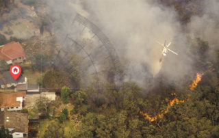
16 April 2018 This blog provides a rapid response to the major bushfires in Sydney’s south-west on the weekend (14-15 April 2018). Unseasonably warm weather (more akin to summer than autumn) caused major bushfires in Sydney’s south-west on Saturday 14 April 2018, posing a serious threat to many properties in nearby suburbs. NSW RFS’ major [...]

27 03, 2018

The March 2018 Bushfire in Tathra, NSW, Australia

2020-10-03T00:49:23+10:00March 27th, 2018|Australia, Bushfire, Earth Observation, Emergency, Image Analysis, Insurance, Location Intelligence, Major Events, Risk|

27 March 2018 It is quite unusual to have extreme fire weather in autumn in Australia, which has caused widespread bushfires (e.g. fires in SW Victoria and fires in the Alpine National Park) and devastating property damage. We have developed and shared three information products in response to the disaster in Tathra, a picturesque town [...]

12 03, 2018

The March 2018 Major Flooding in North Queensland, Australia

2020-10-03T00:49:23+10:00March 12th, 2018|Australia, Earth Observation, Elevation, Emergency, Flood, Insurance, Location Intelligence, Major Events, Risk|

12 March 2018 Devastating flooding once again took place in the North Queensland region. The Bureau of Meteorology had issued major flood warnings for quite a few river catchments, including: Herbert River Murray River Tully River Johnstone River Russell River Mulgrave River Among the regional cities and towns affected, Ingham has suffered the most damage as [...]

15 12, 2017

Progress in 2017: Advancing Emergency and Insurance Applications Using Geospatial Big Data Analytics and Global Earth Observation

2020-10-03T00:49:23+10:00December 15th, 2017|Asia, Australia, Earth Observation, Emergency, Geospatial Big Data Analytics, Insurance, Location Intelligence, Risk|

15 December 2017 Time flies and another year comes to an end. This blog summarises and highlights what we have achieved during 2017. Our vision has been to create innovative location-centric applications using Geospatial Big Data Analytics, Global Earth Observation and Cloud Computing. Location intelligence is becoming ubiquitous and increasingly important for a wide range of [...]

21 11, 2017

Introducing Three New Tools for Investigating Flood-prone Areas in the U.S. and Australia

2020-10-03T00:49:23+10:00November 21st, 2017|Australia, Elevation, Flood, Location Intelligence, Property Information, Risk, USA|

21 November 2017 Flood mapping for large areas (e.g. from catchments to a national level) is relatively new and challenging; associating mapped flood-prone areas with an annual chance of occurrence (in probabilities, say 1%) of a flood event involves many kinds of uncertainties and is even harder. Flood maps that suggest various hazard levels over [...]

25 10, 2017

Visualising Potential Bushfire Risk for Addresses in Australia: A New Cloud-based Approach

2020-10-03T00:49:24+10:00October 25th, 2017|Australia, Bushfire, Earth Observation, Location Intelligence, News Media, Property Information, Risk|

25 October 2017 It's well known that hundreds of thousands of Australian properties (e.g. residential, commercial and industrial) at the urban-bushland interface are very prone to damaging bushfires. Increasing population, urban encroachment into bushland and a dangerous warming climate all suggest that bushfire risk is on the increase. Bushfire risk assessment has been a [...]

28 08, 2017

News Release: BigData Earth Offers Cloud-based Rapid LOCATION Analytics For The News Media Worldwide

2021-01-13T13:13:00+11:00August 28th, 2017|Asia, Australia, Earth Observation, Location Intelligence, Major Events, News Media, Risk, USA|

Location information is critical for news reporting, especially in the event of emergencies, natural disasters, industrial pollution, etc. Relevant location information and insights can not only make the news story more detailed and interesting, but also help readers understand each event and its context more quickly. BigData Earth has been developing unique location [...]

10 08, 2017

New Study: Rapid Exposure Accumulation in Australia’s Coastal Region from 2006 to 2016

2020-10-03T00:49:30+10:00August 10th, 2017|Australia, Census, Exposure, Location Intelligence, Property Information|

10 August 2017 In the previous post, we presented the increase of Australian population and residential dwellings from 2006 to 2016, and how they vary across States and Territories. In this post, we report how much and how fast exposure has changed in coastal regions during the same period. (Australia is sometimes seen as the world’s largest [...]

10 08, 2017

Exposure Changes in Australia: Time Series Profiles of Population and Residential Dwellings from Censuses 2006, 2011 and 2016

2020-10-03T00:49:31+10:00August 10th, 2017|Australia, Census, Exposure, Location Intelligence, Property Information|

10 August 2017 The Australian Bureau of Statistics (ABS) has recently released the first batch of 2016 Census data, and its DataPacks can be obtained here. The new time series profiles on community characteristics provide a unique perspective on how Australian exposure has been changing over the past decade. In this post, we report population [...]

3 04, 2017

Visualising Low-lying Areas in Response to Major Flooding: Case Studies in Rockhampton and Bundaberg, Queensland

2021-01-13T11:54:25+11:00April 3rd, 2017|Australia, Earth Observation, Elevation, Flood, Location Intelligence, Major Events, Risk|

3 April 2017 Last Friday we developed two animations that show estimated flood extents of the major floods in Lismore and Murwillumbah, northern NSW. Today we extend that work and apply the same technique to effectively map and visualise many low-lying, flood-prone areas in Queensland. We choose the following two areas for demonstration: Rockhampton [...]

Go to Top