31 03, 2017

Rapidly Estimating the Flood Extent of Major Floods in Lismore and Murwillumbah on 31 March 2017: Animated Maps Included

2021-01-13T00:47:09+11:00March 31st, 2017|Australia, Earth Observation, Elevation, Flood, Location Intelligence, Major Events, Risk|

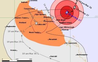
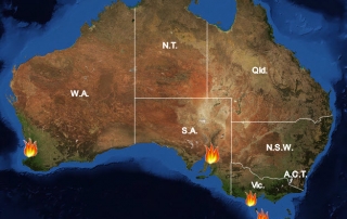
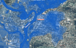
Initial release: 31 March 2017 The south-east QLD and northern NSW are often afflicted with widespread flooding caused by the torrential rain typically associated with ex-cyclones, and this time with the remnants of severe Tropical Cyclone Debbie which made landfall on the QLD coast between Bowen and Mackay on 28 March 2017.  Based on [...]

27 03, 2017

The March 2017 Tropical Cyclone Debbie: Three Exposure Location Profile Reports for Sites in Townsville, Bowen and Mackay, Queensland

2021-04-16T14:55:53+10:00March 27th, 2017|Australia, Earth Observation, Location Intelligence, Major Events, Property Information|

27 March 2017 It is forecast that Tropical Cyclone Debbie will cause severe damage to the coastal region spanning from Townsville in the north to Mackay in the south. It will make landfall near Bowen. Figure 1: Latest track forecast for TC Debbie (Source: BoM) We use a newly-developed national platform to [...]

27 03, 2017

Developing Exposure Location Profile Report for Emergency and Insurance Applications: A National Platform

2020-10-03T00:49:45+10:00March 27th, 2017|Australia, Earth Observation, Image Analysis, Location Intelligence, Property Information, Real Estate|

27 March 2017 BigData Earth has been developing cloud-based solutions for delivering property (exposure) location profile reports, and one of these is for emergency and insurance applications (e.g. emergency planning and response, and insurance underwriting). For locations, addresses or sites in Australia, a national platform and web portal has been developed: https://propertylocation.com.au/georisk.html Main [...]

9 03, 2017

PropertyLocation.com.au: Making Property (Exposure) Location Profile Reports for Australian Addresses on the Cloud

2020-10-03T00:49:48+10:00March 9th, 2017|Asset Management, Australia, Earth Observation, Image Analysis, Location Intelligence, Property Information, Real Estate|

9 March 2017 BigData Earth is pleased to release https://www.PropertyLocation.com.au/, a new web portal where consumers and professionals can quickly request property (exposure) location profile reports for Australian addresses and sites. Location, location, location - For industries such as real estate, asset management and insurance underwriting, the location information is among the most [...]

5 12, 2016

BigData Earth Develops New Location Profile Report for Worldwide Agricultural Land

2021-02-04T11:37:39+11:00December 5th, 2016|Agriculture, Asia, Asset Management, Australia, Climate Change, Cloud Computing, Earth Observation, Flood, Geospatial Big Data Analytics, Image Analysis, Location Intelligence, Property Information, USA|

Modern Earth observation technologies (spaceborne, airborne and terrestrial) are increasingly deployed to capture environmental attributes about agricultural land and assets. Geospatial big data collected by various sensors and the information extracted are critical for the growing AgTech and digital agriculture business. Many baseline terrain and environmental metrics for agricultural land should be systematically [...]

17 11, 2016

Mapping the Early November 2016 Bushfire Burnt Areas in Sydney-Newcastle Region, with Sentinel-2 Satellite Imagery

2020-10-03T00:49:52+10:00November 17th, 2016|Australia, Bushfire, Earth Observation, Image Analysis, Major Events, Sentinel-2|

The 2016-2017 bushfire season in New South Wales started early. In early November (the last month of spring in Australia), three large bushfires broke out near populated areas and drew much attention: The fire near Cranebrook and Llandilo, Western Sydney The fire near Cessnock, Hunter Valley The fire near Karuah, ~35 km north of [...]

3 11, 2016

BigData Earth Develops New-generation Property Location Information for Addresses in the U.S. and Australia

2020-10-03T00:49:54+10:00November 3rd, 2016|Asset Management, Australia, Climate Change, Earth Observation, Elevation, Location Intelligence, Property Information, Real Estate, Risk, USA|

3 November 2016 For industries such as asset management, real estate and insurance underwriting, the location information of assets (e.g. buildings, infrastructure facilities, and agricultural land) is among the most important. Through deep research and development, BigData Earth creates new-generation property location metrics and insights by integrating various thematic layers (including terrain, land cover, climate change, natural [...]

3 11, 2016

Location Profile Reports on Climate Warming Trends

2020-10-03T00:49:55+10:00November 3rd, 2016|Australia, Climate Change, Property Information|

As part of new asset / property location information, we are making reports on location-specific climate warming trend. It is based on the analysis of the new NASA Earth Exchange Global Daily Downscaled Projections dataset (NEX-GDDP, 2015), which is derived from the runs of 21 advanced Global Climate Models under two greenhouse gas emissions scenarios [...]

8 03, 2016

Major Bushfires in Australia in 2015-2016 Summer: Before and After Satellite Imagery

2020-10-03T00:50:05+10:00March 8th, 2016|Australia, Bushfire, Climate Change, Earth Observation, Image Analysis, Landsat, Major Events, Wildfire|

8 March 2016 (We thank the Australian Broadcasting Corporation - ABC - for promoting this for the general public. Twitter, ABC website) Extreme temperatures, frequent heatwaves and prolonged drought (link), enhanced by one of the most powerful El Niño events, have once again caused many bushfires in Australia in 2015-2016 summer season. Major damaging bushfires (grass fires and forest fires) [...]

5 03, 2016

The Warming Trend across Australia in 2100

2020-10-03T00:50:06+10:00March 5th, 2016|Australia, Climate Change|

Statements on the warming climate are supported by two main research approaches: observation and modelling. Observation: It has long been diagnosed that the Earth has a fever, and some latest measurements and facts are alarming: 2015 was the hottest on record globally; January 2016 was the hottest month on record globally (link); February 2016 had record warmth in [...]

Go to Top