22 05, 2019

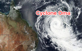
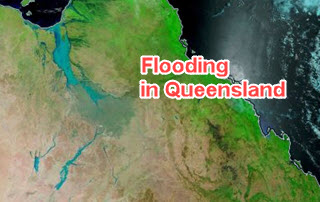
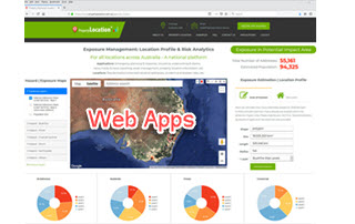
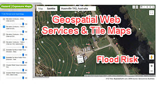
Two Additional Tools to Advance Flood Risk Analytics at Scale in Australia

2021-01-29T13:10:18+11:00May 22nd, 2019|APIs, Apps, Australia, Emergency, Exposure, Flood, Geospatial Big Data Analytics, Insurance, Location Intelligence, Property Information, Risk|

Initial release: 22 May 2019 Over the past few years we have been active developing site-level flood risk analytics tools, e.g. - Introducing Three New Tools for Investigating Flood-prone Areas (link, 11/2017) - Advancing Flood Risk Analytics with Location Profile APIs (link, 09/2018) Now we are pleased to release two additional new [...]

22 02, 2019

The February 2019 Tropical Cyclone Oma, Australia

2021-04-16T15:03:29+10:00February 22nd, 2019|Apps, Asset Management, Australia, Earth Observation, Emergency, Exposure, Geospatial Big Data Analytics, Insurance, Location Intelligence, Major Events, Risk, Tropical Cyclone|

22 February 2019 It's good news that tropical cyclone Oma has weakened and remains offshore. Here we perform some quick analysis using the web APIs & Apps recently developed, and share results with the public (see Twitter posts below). 1. Overview of Current Exposure Why are we so concerned about this event? [...]

11 02, 2019

Some Exposure Analysis in Relation to the February 2019 Flooding in West & North-West Queensland

2020-12-11T15:03:34+11:00February 11th, 2019|Apps, Asset Management, Australia, Earth Observation, Emergency, Exposure, Flood, Geospatial Big Data Analytics, Image Analysis, Insurance, Location Intelligence, Major Events, Property Information, Risk|

11 February 2019 We have been active in reporting and sharing information about the major flooding in Queensland (link to Twitter posts and mass media mentions, e.g. CNN and The Guardian). This brief blog is specific to the flooding in West and North-West Queensland. First, the big picture. We use NASA’s Terra/MODIS imagery (2019-01-02 vs. [...]

28 01, 2019

Releasing a New Web Mapping, Analysis and Reporting App on Exposure Management

2020-10-03T00:49:11+10:00January 28th, 2019|APIs, Apps, Asia, Asset Management, Australia, Bushfire, Emergency, Exposure, Flood, Geospatial Big Data Analytics, Insurance, Location Intelligence, Major Events, Property Information, Risk, USA|

28 January 2019 Over the past few years we have been building cloud-based big data and analytics platforms and foundational Location Profile APIs for property location and hazard risk information. These advances have enabled us to speed up the pace of new product development. Now we are pleased to release a new web [...]

12 12, 2018

Reducing Uncertainties in Catastrophe Loss Modelling: New Advances

2021-01-13T13:08:02+11:00December 12th, 2018|APIs, Asia, Australia, Bushfire, Earth Observation, Exposure, Geospatial Big Data Analytics, Hurricane, Insurance, Location Intelligence, Property Information, Risk, Tropical Cyclone, USA|

12 December 2018 This is our 2018 end-of-year review article. Catastrophe loss modelling, as a special type of environmental modelling, has been around for three decades. It captures all essential components of the classic risk equation, i.e. Risk = f (Hazard, Exposure, Vulnerability), and quantifies the likely economic or insured losses arising [...]

22 10, 2018

Advancing Tropical Cyclone Risk Analytics with Location Profile APIs

2021-03-08T14:08:28+11:00October 22nd, 2018|APIs, Asia, Australia, Emergency, Exposure, Hurricane, Insurance, Location Intelligence, Risk, Tropical Cyclone, Typhoon, USA|

22 October 2018 This project is focused on the analysis of historical tropical cyclones (also known as hurricanes or typhoons) and related wind records, including track positions, wind speed and central pressure. We have developed an automated process of carrying out such analyses on the cloud and enabled by web APIs. A straightforward [...]

2 10, 2018

Advancing Bushfire Risk Analytics with Location Profile APIs: Showcases

2021-01-10T13:37:21+11:00October 2nd, 2018|APIs, Australia, Bushfire, Elevation, Emergency, Exposure, Insurance, Location Intelligence, Property Information, Risk, USA|

2 October 2018 Bushfire (wildfire or forest fire) risk assessment has been a very common topic in research and practice. Many risk analysis projects, such as identifying likely causes of fire occurrences, mapping fire-prone areas and assessing Bushfire Attack Level (BAL) for buildings, are in place to assist the whole process of bushfire risk [...]

25 09, 2018

Advancing Flood Risk Analytics with Location Profile APIs: Showcases

2021-01-13T12:19:35+11:00September 25th, 2018|APIs, Asia, Australia, Elevation, Emergency, Exposure, Flood, Insurance, Location Intelligence, Property Information, Risk, USA|

25 September 2018 For flood risk assessment, one may develop flood hazard maps directly or just use existing maps which are often associated with modelled hazard return periods. The quality of each flood map is up to a range of factors, such as the quality of elevation and rainfall inputs, modelling methods, and [...]

31 08, 2018

Monitoring Major Events with Global Earth Observation and Geospatial Big Data Analytics: 10+ New Examples

2020-10-03T00:49:18+10:00August 31st, 2018|Asia, Australia, Bushfire, Earth Observation, Emergency, Image Analysis, Major Events, News Media, Risk, Sentinel-2, USA, Wildfire|

31 August 2018 This blog summarises some of our latest activities of monitoring, modelling and mapping major hazardous events with Earth observation and geospatial big data analytics, the two methods that are increasingly important and indispensable for a wide range of environmental studies. We routinely apply our own advanced image analysis software (Spectral Discovery) [...]

31 08, 2018

Location Profile APIs Out of Beta

2020-10-03T00:49:20+10:00August 31st, 2018|APIs, Asia, Asset Management, Exposure, Geospatial Big Data Analytics, Insurance, Location Intelligence, Property Information, Real Estate, Risk|

31 August 2018 We are pleased to release property/exposure Location Profile APIs (Version 2.0), out of beta! (Link to an initial release and introduction is here.) More than ten APIs are currently available for property location and hazard risk intelligence. Main applications: Property location information, emergency planning and response, insurance underwriting and claims, news media [...]

Go to Top