2 04, 2020

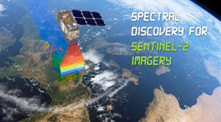
Unique Software Spectral Discovery to Easily and Rapidly Process Sentinel-2 Imagery

2021-01-13T18:26:09+11:00April 2nd, 2020|Agriculture, Asia, Australia, Bushfire, Earth Observation, Emergency, Image Analysis, Major Events, News Media, Risk, Sentinel-2, USA, Wildfire|

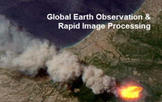
2 April 2020 Sentinel-2 (with twin satellites Sentinel-2A and Sentinel-2B) is one of the most successful Earth observation missions from the EU Copernicus Programme and ESA. Sentinel-2 satellite imagery features: wide swath (290km) multiple spectral bands (13 bands) high resolution (four visible and near-infrared bands at 10m, six red-edge/shortwave-infrared bands at 20m, and three [...]

22 10, 2018

Advancing Tropical Cyclone Risk Analytics with Location Profile APIs

2024-06-02T23:12:59+10:00October 22nd, 2018|APIs, Asia, Australia, Emergency, Exposure, Hurricane, Insurance, Location Intelligence, Risk, Tropical Cyclone, Typhoon, USA|

22 October 2018 This project is focused on the analysis of historical tropical cyclones (also known as hurricanes or typhoons) and related wind records, including track positions, wind speed and central pressure. We have developed an automated process of carrying out such analyses on the cloud and enabled by web APIs. A straightforward [...]

2 10, 2018

Advancing Bushfire Risk Analytics with Location Profile APIs: Showcases

2025-08-05T20:23:10+10:00October 2nd, 2018|APIs, Australia, Bushfire, Elevation, Emergency, Exposure, Insurance, Location Intelligence, Property Information, Risk, USA|

2 October 2018 Bushfire (wildfire or forest fire) risk assessment has been a very common topic in research and practice. Many risk analysis projects, such as identifying likely causes of fire occurrences, mapping fire-prone areas and assessing Bushfire Attack Level (BAL) for buildings, are in place to assist the whole process of bushfire risk [...]

25 09, 2018

Advancing Flood Risk Analytics with Location Profile APIs: Showcases

2025-08-05T20:20:43+10:00September 25th, 2018|APIs, Asia, Australia, Elevation, Emergency, Exposure, Flood, Insurance, Location Intelligence, Property Information, Risk, USA|

25 September 2018 For flood risk assessment, one may develop flood hazard maps directly or just use existing maps which are often associated with modelled hazard return periods. The quality of each flood map is up to a range of factors, such as the quality of elevation and rainfall inputs, modelling methods, and [...]

21 09, 2018

Assessing the Impact of the September 2018 Hurricane Florence

2020-10-03T00:49:17+10:00September 21st, 2018|APIs, Earth Observation, Exposure, Flood, Hurricane, Image Analysis, Insurance, Location Intelligence, Major Events, Tropical Cyclone, Typhoon, USA|

21 September 2018 Hurricane Florence made landfall near Wrightsville Beach, North Carolina at 7:15 AM on Friday (14 September 2018) as a Category 1 hurricane. This blog summarises some of our existing information products and new analytics that can be used to help assess the impact of this major event. 1. Location [...]

31 08, 2018

Monitoring Major Events with Global Earth Observation and Geospatial Big Data Analytics: 10+ New Examples

2020-10-03T00:49:18+10:00August 31st, 2018|Asia, Australia, Bushfire, Earth Observation, Emergency, Image Analysis, Major Events, News Media, Risk, Sentinel-2, USA, Wildfire|

31 August 2018 This blog summarises some of our latest activities of monitoring, modelling and mapping major hazardous events with Earth observation and geospatial big data analytics, the two methods that are increasingly important and indispensable for a wide range of environmental studies. We routinely apply our own advanced image analysis software (Spectral Discovery) [...]

8 06, 2018

Introducing Location Profile APIs for Property Location and Hazard Risk Intelligence

2024-06-02T22:50:52+10:00June 8th, 2018|APIs, Asia, Asset Management, Australia, Exposure, Geospatial Big Data Analytics, Insurance, Location Intelligence, Property Information, Real Estate, Risk, USA|

8 June 2018 The public release of BigData Earth's Location Profile APIs is a milestone in our vision of achieving API-first, cloud-based big data analytics and innovative solutions. [Update 31 August 2018: APIs Version 2.0 out of beta] The set of APIs released now reflects our substantial R&D in the following major applications over [...]

15 12, 2017

Progress in 2017: Advancing Emergency and Insurance Applications Using Geospatial Big Data Analytics and Global Earth Observation

2020-10-03T00:49:23+10:00December 15th, 2017|Asia, Australia, Earth Observation, Emergency, Geospatial Big Data Analytics, Insurance, Location Intelligence, Risk|

15 December 2017 Time flies and another year comes to an end. This blog summarises and highlights what we have achieved during 2017. Our vision has been to create innovative location-centric applications using Geospatial Big Data Analytics, Global Earth Observation and Cloud Computing. Location intelligence is becoming ubiquitous and increasingly important for a wide range of [...]

28 08, 2017

News Release: BigData Earth Offers Cloud-based Rapid LOCATION Analytics For The News Media Worldwide

2021-01-13T13:13:00+11:00August 28th, 2017|Asia, Australia, Earth Observation, Location Intelligence, Major Events, News Media, Risk, USA|

Location information is critical for news reporting, especially in the event of emergencies, natural disasters, industrial pollution, etc. Relevant location information and insights can not only make the news story more detailed and interesting, but also help readers understand each event and its context more quickly. BigData Earth has been developing unique location [...]

Go to Top