3 04, 2017

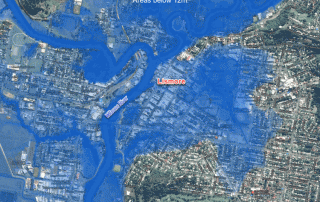
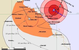
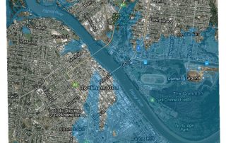
Visualising Low-lying Areas in Response to Major Flooding: Case Studies in Rockhampton and Bundaberg, Queensland

2025-08-05T20:12:37+10:00April 3rd, 2017|Australia, Earth Observation, Elevation, Flood, Location Intelligence, Major Events, Risk|

3 April 2017 Last Friday we developed two animations that show estimated flood extents of the major floods in Lismore and Murwillumbah, northern NSW. Today we extend that work and apply the same technique to effectively map and visualise many low-lying, flood-prone areas in Queensland. We choose the following two areas for demonstration: Rockhampton [...]

31 03, 2017

Rapidly Estimating the Flood Extent of Major Floods in Lismore and Murwillumbah on 31 March 2017: Animated Maps Included

2025-08-05T20:07:04+10:00March 31st, 2017|Australia, Earth Observation, Elevation, Flood, Location Intelligence, Major Events, Risk|

Initial release: 31 March 2017 The south-east QLD and northern NSW are often afflicted with widespread flooding caused by the torrential rain typically associated with ex-cyclones, and this time with the remnants of severe Tropical Cyclone Debbie which made landfall on the QLD coast between Bowen and Mackay on 28 March 2017.  Based on [...]

27 03, 2017

The March 2017 Tropical Cyclone Debbie: Three Exposure Location Profile Reports for Sites in Townsville, Bowen and Mackay, Queensland

2025-08-05T20:15:40+10:00March 27th, 2017|Australia, Earth Observation, Location Intelligence, Major Events, Property Information|

27 March 2017 It is forecast that Tropical Cyclone Debbie will cause severe damage to the coastal region spanning from Townsville in the north to Mackay in the south. It will make landfall near Bowen. Figure 1: Latest track forecast for TC Debbie (Source: BoM) We use a newly-developed national platform to [...]

27 03, 2017

Developing Exposure Location Profile Report for Emergency and Insurance Applications: A National Platform

2020-10-03T00:49:45+10:00March 27th, 2017|Australia, Earth Observation, Image Analysis, Location Intelligence, Property Information, Real Estate|

27 March 2017 BigData Earth has been developing cloud-based solutions for delivering property (exposure) location profile reports, and one of these is for emergency and insurance applications (e.g. emergency planning and response, and insurance underwriting). For locations, addresses or sites in Australia, a national platform and web portal has been developed: https://propertylocation.com.au/georisk.html Main [...]

9 03, 2017

PropertyLocation.com.au: Making Property (Exposure) Location Profile Reports for Australian Addresses on the Cloud

2020-10-03T00:49:48+10:00March 9th, 2017|Asset Management, Australia, Earth Observation, Image Analysis, Location Intelligence, Property Information, Real Estate|

9 March 2017 BigData Earth is pleased to release https://www.PropertyLocation.com.au/, a new web portal where consumers and professionals can quickly request property (exposure) location profile reports for Australian addresses and sites. Location, location, location - For industries such as real estate, asset management and insurance underwriting, the location information is among the most [...]

5 12, 2016

BigData Earth Develops New Location Profile Report for Worldwide Agricultural Land

2021-02-04T11:37:39+11:00December 5th, 2016|Agriculture, Asia, Asset Management, Australia, Climate Change, Cloud Computing, Earth Observation, Flood, Geospatial Big Data Analytics, Image Analysis, Location Intelligence, Property Information, USA|

Modern Earth observation technologies (spaceborne, airborne and terrestrial) are increasingly deployed to capture environmental attributes about agricultural land and assets. Geospatial big data collected by various sensors and the information extracted are critical for the growing AgTech and digital agriculture business. Many baseline terrain and environmental metrics for agricultural land should be systematically [...]

Go to Top