18 04, 2018

New Dataset – ABS Socio-Economic Indexes for Areas (SEIFA) – to Enhance Property Location Profile Report

2020-10-03T00:49:23+10:00April 18th, 2018|Australia, Census, Exposure, Location Intelligence, Property Information|

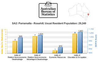
18 April 2018 The Australian Bureau of Statistics (ABS) released the long-awaited Socio-Economic Indexes for Areas (SEIFA, based on 2016 Census) dataset on 27 March 2018 (link). SEIFA is a modelled measure by integrating a wide range of social and economic attributes about the Australian population in an geographic area. SEIFA is generally regarded as one [...]

16 04, 2018

The April 2018 Bushfire in Sydney’s South-west, NSW, Australia

2020-10-03T00:49:23+10:00April 16th, 2018|Australia, Bushfire, Earth Observation, Emergency, Image Analysis, Insurance, Location Intelligence, Major Events, Risk|

16 April 2018 This blog provides a rapid response to the major bushfires in Sydney’s south-west on the weekend (14-15 April 2018). Unseasonably warm weather (more akin to summer than autumn) caused major bushfires in Sydney’s south-west on Saturday 14 April 2018, posing a serious threat to many properties in nearby suburbs. NSW RFS’ major [...]

27 03, 2018

The March 2018 Bushfire in Tathra, NSW, Australia

2020-10-03T00:49:23+10:00March 27th, 2018|Australia, Bushfire, Earth Observation, Emergency, Image Analysis, Insurance, Location Intelligence, Major Events, Risk|

27 March 2018 It is quite unusual to have extreme fire weather in autumn in Australia, which has caused widespread bushfires (e.g. fires in SW Victoria and fires in the Alpine National Park) and devastating property damage. We have developed and shared three information products in response to the disaster in Tathra, a picturesque town [...]

12 03, 2018

The March 2018 Major Flooding in North Queensland, Australia

2020-10-03T00:49:23+10:00March 12th, 2018|Australia, Earth Observation, Elevation, Emergency, Flood, Insurance, Location Intelligence, Major Events, Risk|

12 March 2018 Devastating flooding once again took place in the North Queensland region. The Bureau of Meteorology had issued major flood warnings for quite a few river catchments, including: Herbert River Murray River Tully River Johnstone River Russell River Mulgrave River Among the regional cities and towns affected, Ingham has suffered the most damage as [...]

8 12, 2017

A Survey and Clarification of DEM Vertical Accuracy

2021-01-10T13:31:47+11:00December 8th, 2017|Earth Observation, Elevation, Flood, Location Intelligence, Risk, USA|

8 December 2017 For flood hazard modelling and risk analysis, Digital Elevation Model (DEM) is indispensable. Probably the most important metric about DEM quality is its vertical accuracy. Unfortunately, it is often confusing in literature and among various data offerings, and there are serious implications for applications, e.g. whether flood hazard rating can be confidently quantified [...]

21 11, 2017

Introducing Three New Tools for Investigating Flood-prone Areas in the U.S. and Australia

2020-10-03T00:49:23+10:00November 21st, 2017|Australia, Elevation, Flood, Location Intelligence, Property Information, Risk, USA|

21 November 2017 Flood mapping for large areas (e.g. from catchments to a national level) is relatively new and challenging; associating mapped flood-prone areas with an annual chance of occurrence (in probabilities, say 1%) of a flood event involves many kinds of uncertainties and is even harder. Flood maps that suggest various hazard levels over [...]

25 10, 2017

Visualising Potential Bushfire Risk for Addresses in Australia: A New Cloud-based Approach

2025-08-05T20:25:42+10:00October 25th, 2017|Australia, Bushfire, Earth Observation, Location Intelligence, News Media, Property Information, Risk|

25 October 2017 It's well known that hundreds of thousands of Australian properties (e.g. residential, commercial and industrial) at the urban-bushland interface are very prone to damaging bushfires. Increasing population, urban encroachment into bushland and a dangerous warming climate all suggest that bushfire risk is on the increase. Bushfire risk assessment has been a [...]

16 10, 2017

Some Imagery Sources for the Northern California Wildfires in October 2017

2020-10-03T00:49:25+10:00October 16th, 2017|Earth Observation, Location Intelligence, Major Events, News Media, USA, Wildfire|

16 October 2017 The catastrophic wildfires in Northern California started a week ago have claimed at least 40 lives and destroyed nearly 6,000 buildings (news report). The fires continuously burning over the past week and the extensive damage have been observed by low-, medium- and high-resolution satellite imagery. Here we summarise and analyse a few useful imagery sources. [...]

10 08, 2017

New Study: Rapid Exposure Accumulation in Australia’s Coastal Region from 2006 to 2016

2020-10-03T00:49:30+10:00August 10th, 2017|Australia, Census, Exposure, Location Intelligence, Property Information|

10 August 2017 In the previous post, we presented the increase of Australian population and residential dwellings from 2006 to 2016, and how they vary across States and Territories. In this post, we report how much and how fast exposure has changed in coastal regions during the same period. (Australia is sometimes seen as the world’s largest [...]

10 08, 2017

Exposure Changes in Australia: Time Series Profiles of Population and Residential Dwellings from Censuses 2006, 2011 and 2016

2020-10-03T00:49:31+10:00August 10th, 2017|Australia, Census, Exposure, Location Intelligence, Property Information|

10 August 2017 The Australian Bureau of Statistics (ABS) has recently released the first batch of 2016 Census data, and its DataPacks can be obtained here. The new time series profiles on community characteristics provide a unique perspective on how Australian exposure has been changing over the past decade. In this post, we report population [...]

Go to Top