18 04, 2018

New Dataset – ABS Socio-Economic Indexes for Areas (SEIFA) – to Enhance Property Location Profile Report

2020-10-03T00:49:23+10:00April 18th, 2018|Australia, Census, Exposure, Location Intelligence, Property Information|

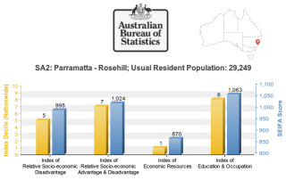
18 April 2018 The Australian Bureau of Statistics (ABS) released the long-awaited Socio-Economic Indexes for Areas (SEIFA, based on 2016 Census) dataset on 27 March 2018 (link). SEIFA is a modelled measure by integrating a wide range of social and economic attributes about the Australian population in an geographic area. SEIFA is generally regarded as one [...]

10 08, 2017

New Study: Rapid Exposure Accumulation in Australia’s Coastal Region from 2006 to 2016

2020-10-03T00:49:30+10:00August 10th, 2017|Australia, Census, Exposure, Location Intelligence, Property Information|

10 August 2017 In the previous post, we presented the increase of Australian population and residential dwellings from 2006 to 2016, and how they vary across States and Territories. In this post, we report how much and how fast exposure has changed in coastal regions during the same period. (Australia is sometimes seen as the world’s largest [...]

10 08, 2017

Exposure Changes in Australia: Time Series Profiles of Population and Residential Dwellings from Censuses 2006, 2011 and 2016

2020-10-03T00:49:31+10:00August 10th, 2017|Australia, Census, Exposure, Location Intelligence, Property Information|

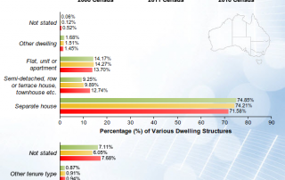
10 August 2017 The Australian Bureau of Statistics (ABS) has recently released the first batch of 2016 Census data, and its DataPacks can be obtained here. The new time series profiles on community characteristics provide a unique perspective on how Australian exposure has been changing over the past decade. In this post, we report population [...]

Go to Top