22 02, 2019

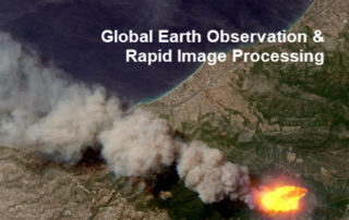
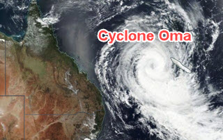
The February 2019 Tropical Cyclone Oma, Australia

2021-04-16T15:03:29+10:00February 22nd, 2019|Apps, Asset Management, Australia, Earth Observation, Emergency, Exposure, Geospatial Big Data Analytics, Insurance, Location Intelligence, Major Events, Risk, Tropical Cyclone|

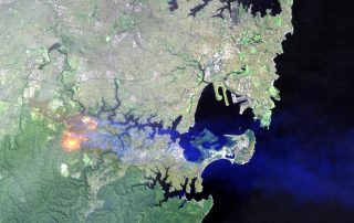
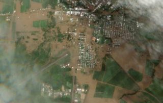
22 February 2019 It's good news that tropical cyclone Oma has weakened and remains offshore. Here we perform some quick analysis using the web APIs & Apps recently developed, and share results with the public (see Twitter posts below). 1. Overview of Current Exposure Why are we so concerned about this event? [...]

11 02, 2019

Some Exposure Analysis in Relation to the February 2019 Flooding in West & North-West Queensland

2020-12-11T15:03:34+11:00February 11th, 2019|Apps, Asset Management, Australia, Earth Observation, Emergency, Exposure, Flood, Geospatial Big Data Analytics, Image Analysis, Insurance, Location Intelligence, Major Events, Property Information, Risk|

11 February 2019 We have been active in reporting and sharing information about the major flooding in Queensland (link to Twitter posts and mass media mentions, e.g. CNN and The Guardian). This brief blog is specific to the flooding in West and North-West Queensland. First, the big picture. We use NASA’s Terra/MODIS imagery (2019-01-02 vs. [...]

12 12, 2018

Reducing Uncertainties in Catastrophe Loss Modelling: New Advances

2021-01-13T13:08:02+11:00December 12th, 2018|APIs, Asia, Australia, Bushfire, Earth Observation, Exposure, Geospatial Big Data Analytics, Hurricane, Insurance, Location Intelligence, Property Information, Risk, Tropical Cyclone, USA|

12 December 2018 This is our 2018 end-of-year review article. Catastrophe loss modelling, as a special type of environmental modelling, has been around for three decades. It captures all essential components of the classic risk equation, i.e. Risk = f (Hazard, Exposure, Vulnerability), and quantifies the likely economic or insured losses arising [...]

21 09, 2018

The September 2018 Super Typhoon Mangkhut: Some Rapid Risk Analyses

2020-10-03T00:49:17+10:00September 21st, 2018|APIs, Asia, Earth Observation, Exposure, Flood, Hurricane, Image Analysis, Insurance, Location Intelligence, Major Events, Tropical Cyclone, Typhoon|

21 September 2018 Super Typhoon Mangkhut made landfall in Guangdong Province, China around 5 PM Sunday (16 September 2018) as a Category 2 hurricane (in Saffir–Simpson hurricane wind scale). This blog summarises a number of rapid analyses we performed and some of our existing information products that can be used to help assess the [...]

21 09, 2018

Assessing the Impact of the September 2018 Hurricane Florence

2020-10-03T00:49:17+10:00September 21st, 2018|APIs, Earth Observation, Exposure, Flood, Hurricane, Image Analysis, Insurance, Location Intelligence, Major Events, Tropical Cyclone, Typhoon, USA|

21 September 2018 Hurricane Florence made landfall near Wrightsville Beach, North Carolina at 7:15 AM on Friday (14 September 2018) as a Category 1 hurricane. This blog summarises some of our existing information products and new analytics that can be used to help assess the impact of this major event. 1. Location [...]

31 08, 2018

Monitoring Major Events with Global Earth Observation and Geospatial Big Data Analytics: 10+ New Examples

2020-10-03T00:49:18+10:00August 31st, 2018|Asia, Australia, Bushfire, Earth Observation, Emergency, Image Analysis, Major Events, News Media, Risk, Sentinel-2, USA, Wildfire|

31 August 2018 This blog summarises some of our latest activities of monitoring, modelling and mapping major hazardous events with Earth observation and geospatial big data analytics, the two methods that are increasingly important and indispensable for a wide range of environmental studies. We routinely apply our own advanced image analysis software (Spectral Discovery) [...]

16 04, 2018

The April 2018 Bushfire in Sydney’s South-west, NSW, Australia

2020-10-03T00:49:23+10:00April 16th, 2018|Australia, Bushfire, Earth Observation, Emergency, Image Analysis, Insurance, Location Intelligence, Major Events, Risk|

16 April 2018 This blog provides a rapid response to the major bushfires in Sydney’s south-west on the weekend (14-15 April 2018). Unseasonably warm weather (more akin to summer than autumn) caused major bushfires in Sydney’s south-west on Saturday 14 April 2018, posing a serious threat to many properties in nearby suburbs. NSW RFS’ major [...]

27 03, 2018

The March 2018 Bushfire in Tathra, NSW, Australia

2020-10-03T00:49:23+10:00March 27th, 2018|Australia, Bushfire, Earth Observation, Emergency, Image Analysis, Insurance, Location Intelligence, Major Events, Risk|

27 March 2018 It is quite unusual to have extreme fire weather in autumn in Australia, which has caused widespread bushfires (e.g. fires in SW Victoria and fires in the Alpine National Park) and devastating property damage. We have developed and shared three information products in response to the disaster in Tathra, a picturesque town [...]

12 03, 2018

The March 2018 Major Flooding in North Queensland, Australia

2020-10-03T00:49:23+10:00March 12th, 2018|Australia, Earth Observation, Elevation, Emergency, Flood, Insurance, Location Intelligence, Major Events, Risk|

12 March 2018 Devastating flooding once again took place in the North Queensland region. The Bureau of Meteorology had issued major flood warnings for quite a few river catchments, including: Herbert River Murray River Tully River Johnstone River Russell River Mulgrave River Among the regional cities and towns affected, Ingham has suffered the most damage as [...]

15 12, 2017

Progress in 2017: Advancing Emergency and Insurance Applications Using Geospatial Big Data Analytics and Global Earth Observation

2020-10-03T00:49:23+10:00December 15th, 2017|Asia, Australia, Earth Observation, Emergency, Geospatial Big Data Analytics, Insurance, Location Intelligence, Risk|

15 December 2017 Time flies and another year comes to an end. This blog summarises and highlights what we have achieved during 2017. Our vision has been to create innovative location-centric applications using Geospatial Big Data Analytics, Global Earth Observation and Cloud Computing. Location intelligence is becoming ubiquitous and increasingly important for a wide range of [...]

Go to Top