21 09, 2018

The September 2018 Super Typhoon Mangkhut: Some Rapid Risk Analyses

2020-10-03T00:49:17+10:00September 21st, 2018|APIs, Asia, Earth Observation, Exposure, Flood, Hurricane, Image Analysis, Insurance, Location Intelligence, Major Events, Tropical Cyclone, Typhoon|

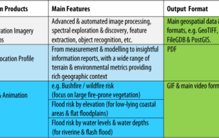
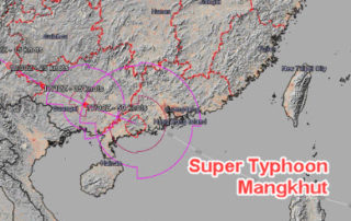
21 September 2018 Super Typhoon Mangkhut made landfall in Guangdong Province, China around 5 PM Sunday (16 September 2018) as a Category 2 hurricane (in Saffir–Simpson hurricane wind scale). This blog summarises a number of rapid analyses we performed and some of our existing information products that can be used to help assess the [...]

21 09, 2018

Assessing the Impact of the September 2018 Hurricane Florence

2020-10-03T00:49:17+10:00September 21st, 2018|APIs, Earth Observation, Exposure, Flood, Hurricane, Image Analysis, Insurance, Location Intelligence, Major Events, Tropical Cyclone, Typhoon, USA|

21 September 2018 Hurricane Florence made landfall near Wrightsville Beach, North Carolina at 7:15 AM on Friday (14 September 2018) as a Category 1 hurricane. This blog summarises some of our existing information products and new analytics that can be used to help assess the impact of this major event. 1. Location [...]

31 08, 2018

Monitoring Major Events with Global Earth Observation and Geospatial Big Data Analytics: 10+ New Examples

2020-10-03T00:49:18+10:00August 31st, 2018|Asia, Australia, Bushfire, Earth Observation, Emergency, Image Analysis, Major Events, News Media, Risk, Sentinel-2, USA, Wildfire|

31 August 2018 This blog summarises some of our latest activities of monitoring, modelling and mapping major hazardous events with Earth observation and geospatial big data analytics, the two methods that are increasingly important and indispensable for a wide range of environmental studies. We routinely apply our own advanced image analysis software (Spectral Discovery) [...]

15 12, 2017

Progress in 2017: Advancing Emergency and Insurance Applications Using Geospatial Big Data Analytics and Global Earth Observation

2020-10-03T00:49:23+10:00December 15th, 2017|Asia, Australia, Earth Observation, Emergency, Geospatial Big Data Analytics, Insurance, Location Intelligence, Risk|

15 December 2017 Time flies and another year comes to an end. This blog summarises and highlights what we have achieved during 2017. Our vision has been to create innovative location-centric applications using Geospatial Big Data Analytics, Global Earth Observation and Cloud Computing. Location intelligence is becoming ubiquitous and increasingly important for a wide range of [...]

28 08, 2017

News Release: BigData Earth Offers Cloud-based Rapid LOCATION Analytics For The News Media Worldwide

2021-01-13T13:13:00+11:00August 28th, 2017|Asia, Australia, Earth Observation, Location Intelligence, Major Events, News Media, Risk, USA|

Location information is critical for news reporting, especially in the event of emergencies, natural disasters, industrial pollution, etc. Relevant location information and insights can not only make the news story more detailed and interesting, but also help readers understand each event and its context more quickly. BigData Earth has been developing unique location [...]

26 06, 2017

Developing Exposure LOCATION Profile for International News Reporting: Take the 2017-06-24 Landslide in SW China as an Example

2020-10-03T00:49:35+10:00June 26th, 2017|Asia, Earth Observation, Landslide, Location Intelligence, Major Events, Risk|

26 June 2017 Location information and insights are becoming ubiquitous and more important than ever. Tangible and easy-to-read location information, mainly through maps and various visualisation techniques, enhances our understanding of many dynamic phenomena. For the current news reporting on major hazardous events taking place around the world, there is a need to include more detailed and coherent [...]

Go to Top