11 08, 2020

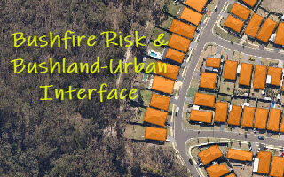
Monitoring Land Cover Changes at the Bushland-Urban Interface: An Image Analysis Approach

2020-12-11T12:13:19+11:00August 11th, 2020|AI, Australia, Bushfire, Climate Change, Cloud Computing, Earth Observation, Emergency, Exposure, Geocoding, Geospatial Big Data Analytics, Image Analysis, Land parcel, Location Intelligence, Property Information, Risk, Sentinel-2|

It has been well observed, modelled and reported that bushfire risk is on the rise under a rapidly warming climate. Earth observation, remote sensing and image analysis are among the most important technologies to manage bushfires nowadays - from disaster prevention to preparedness, from hotspots detection to movement monitoring, from response to recovery, [...]

11 08, 2020

Building-level Geocoding for Regional Flood Risk Analysis: A Case Study in Ipswich, Queensland

2020-10-03T00:48:32+10:00August 11th, 2020|AI, Australia, Cloud Computing, Earth Observation, Exposure, Flood, Geocoding, Geospatial Big Data Analytics, Image Analysis, Land parcel, Location Intelligence, Property Information, Risk|

One of our recent blogs discussed the importance of building-level geocoding for flood risk analysis (link). If an exposure is wrongly or insufficiently geocoded, corresponding flood risk could be very different. In some extreme cases, the risk could be more than an order of magnitude different. Figure 1 shows a comparison of parcel-level [...]

29 07, 2020

Mapping the Coastal Settlement in Wamberal, NSW: Two Approaches

2020-10-03T00:48:34+10:00July 29th, 2020|AI, Australia, Cloud Computing, Earth Observation, Elevation, Exposure, Flood, Geocoding, Geospatial Big Data Analytics, Image Analysis, Land parcel, Location Intelligence, Property Information, Risk|

Quite a few coastal properties in Wamberal (NSW) are at risk of constant coastal erosion. This is again heightened by the threat from two Australian East Coast Lows affecting the NSW coast in recent few weeks. Two independent approaches, together with high-resolution public data sources, can be used to map the coastal settlement. [...]

21 07, 2020

Creating Building Footprints and Terrain Features for Web and Desktop Mapping: With Examples from the NSW Coast

2021-04-30T10:22:52+10:00July 21st, 2020|AI, Australia, Cloud Computing, Earth Observation, Elevation, Exposure, Flood, Geocoding, Geospatial Big Data Analytics, Image Analysis, Land parcel, Location Intelligence, Property Information, Risk|

High-resolution digital imagery (satellite, aerial or drone-based) and high-resolution elevation data (typically derived from LiDAR point clouds) are increasingly used in local and regional environmental studies. But it is still challenging to extract high-resolution feature attributes (e.g. building footprints from imagery and terrain metrics from digital elevation models) for deeper geospatial analysis and [...]

1 07, 2020

Building-level Geocoding of G-NAF (Address Database) for Improved Flood & Bushfire Risk Analysis in Australia

2021-02-25T10:50:24+11:00July 1st, 2020|AI, Bushfire, Cloud Computing, Earth Observation, Exposure, Flood, Geocoding, Geospatial Big Data Analytics, Image Analysis, Land parcel, Location Intelligence, Property Information, Risk|

It is well known that exposure location is a major source of uncertainties in either site-level or aggregate risk analysis. Back in 2016, we released a product called Geocoding DoubleCheck (link) to address the location accuracy of parcel-level geocoding. Then we compared the difference between parcel-level and building-level geocoding (Figure 1), and stressed [...]

25 09, 2018

Advancing Flood Risk Analytics with Location Profile APIs: Showcases

2025-08-05T20:20:43+10:00September 25th, 2018|APIs, Asia, Australia, Elevation, Emergency, Exposure, Flood, Insurance, Location Intelligence, Property Information, Risk, USA|

25 September 2018 For flood risk assessment, one may develop flood hazard maps directly or just use existing maps which are often associated with modelled hazard return periods. The quality of each flood map is up to a range of factors, such as the quality of elevation and rainfall inputs, modelling methods, and [...]

21 09, 2018

The September 2018 Super Typhoon Mangkhut: Some Rapid Risk Analyses

2020-10-03T00:49:17+10:00September 21st, 2018|APIs, Asia, Earth Observation, Exposure, Flood, Hurricane, Image Analysis, Insurance, Location Intelligence, Major Events, Tropical Cyclone, Typhoon|

21 September 2018 Super Typhoon Mangkhut made landfall in Guangdong Province, China around 5 PM Sunday (16 September 2018) as a Category 2 hurricane (in Saffir–Simpson hurricane wind scale). This blog summarises a number of rapid analyses we performed and some of our existing information products that can be used to help assess the [...]

21 09, 2018

Assessing the Impact of the September 2018 Hurricane Florence

2020-10-03T00:49:17+10:00September 21st, 2018|APIs, Earth Observation, Exposure, Flood, Hurricane, Image Analysis, Insurance, Location Intelligence, Major Events, Tropical Cyclone, Typhoon, USA|

21 September 2018 Hurricane Florence made landfall near Wrightsville Beach, North Carolina at 7:15 AM on Friday (14 September 2018) as a Category 1 hurricane. This blog summarises some of our existing information products and new analytics that can be used to help assess the impact of this major event. 1. Location [...]

Go to Top